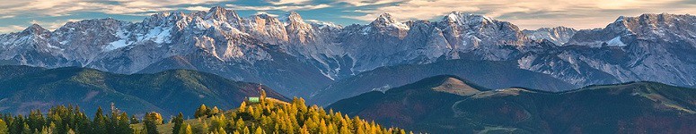
Rakousko, Dachstein: Der Johann – A Long Klettersteig on the Steep Southern Slope I.

Easy ascent of the terrain is followed by steep climb along Mitterstein mountain. There you will see the first sunlight spilling over the massif. While on Mitterstein, you will see a summit cross in the distance. Also, you will notice people with helmets who just reached the summit of Anna klettersteig ferrata. Then follow a well trodden road which goes across brash until you get to a steep rock wall. Here you can spot old snow. Soon you will see boarding to the Der Johann klettersteig ferrata.

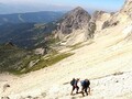
Finally, we reach 2200 meters of altitude. About 540 elevation meters of a secured trai is ahead fo us. Let's take on the needed eqipment (helmet, sit harness, and a ferrata set) and we can start. The trail starts easy on two boulders under massif. Then you get on the rock wall and you get the very hard difficulty (E) right at the outset. It is an overhang and you need to move your carabiners. This is really difficult for your muscles are probably not warmed up. The hardest section is a great feature made by the designers of the trail. Those who are not fit enough to climb this klettersteig will have been worn out here already. Should the most difficult section be higher, it would mean a large problem. The ferratas are one-way only (up).


The following sections are not the most difficult but also not a piece of cake. There are natural rests. Where these rests are missing there are rests made of steel. The section which gets you to the first break area is graduating slowly (A, B, B/C) and is situated at 2380 m. There is enough of place where can be without fall protection. You can sit on a rock and look down on the brash or up on the artificial steep section of the klettersteig, at which you will get anyway. Also, you can just move on and go around people resting here.

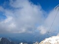
The trail towards the second of the resting areas Südwandblick at 2510 m is much more interesting. There you will try the height of the massive wall. Majority of this section is a steep massif. You go steeply uphill. You have to cross the sections of C and D difficulty. However, the climbing is quite ok. However, one might get sick of looking below himself. Then you cross one A section and get on a recreational trail of Südwandblick. Yet snow and wet rock would be bit complicating for progressing onwards but you would cross another 130 meters of elevation. At the end of this section you can find the memorial summit book. Actually, it is not situated on the top of the montain for every tourist who takes a cable car would be able to inscribe his name to the book and obviously the builders of this trail did want to prevent this. There are many Czech stickers on the metal box inside which the book is. Czechs are frequent visitors to this place.

And how would our journey continue? You can read about it next week.
GPS: 47°28'18.2"N 13°38'06.0"E
Text and photos: Martina Brožková
| Discussion at the article (0) |
Related Articles

Austria – Winter Vacation in the Region of Salzburg
Austria, Dachstein: Hoher Dachstein – Climbing the Highest Summit

Austria, Dachstein: Der Johann – Long Klettersteig Along Steep Southern Slope II.

Austria: Schladming-Dachstein – Different Winter Joys
Austria: Skiing in the Alps I – Dachstein West, a Village Type Ski Resort

Austria: Green, Mountainous Country – VIDEO

Austria: Secured Trail in Johnsbach

Austria: Dachstein – Mountain Range in the Northern Limestone Alps

Austria, Dachstein: Mountain Giant – The Northewestern Part of the Massif

Austria, Dachstein: Mountain Giant – Southern Slopes

Austria, Dachstein – Rocky Giant
Related Photogallery

Austria: Schladming-Dachstein Winter Paradise
Related Videos

Austria: Green, Mountainous Country


Guide:
Important Information:
![]() Information and warnings on travelling abroad is to be found HERE.
Information and warnings on travelling abroad is to be found HERE.
Mobile application:

![]()
![]()