
River Jizerka - Czech republic
The river collects its sources in Giant Mountains near to Horní Mísečly in the altitude of 1065 m of the sea level.
21 km
| Basic information about river river sections Kilometrage Localites | Services Article Fotogallery Videogallery | Discussion Water stages |
River description:
Jizerka river is navigable in spring within snow-thaw period or after strong rains. The navigability can be estimated according to Jizera water-stand approximately but Jizerka-river has much more smaller water-basin. Higher water-level is flown throughout the river-bed during short period only. It is necessary to investigate the upper section in advance as there is a danger of laying trees in a bed. The navigation along Jizerka, if we do not meet the unexpected obstacle, is quite quick. The experienced waterman drives the whole section within 2 hours. The descend of Jizerka can be joined with a navigation of the other rivers in the surroundings.
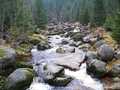
Jizerka is bound for the south first, near to Jilemnice turns to the west to its mouth with Jizera at Horní Sytová. Its river-basin makes 86 km2 only. Jizerka flows,on its whole flow, through narrow, afforested valley, which opens moderately before its mouth. The slope of the river is big and decreases successively. Its river bed is rocky and stony at first , near to Hrabačov the water-level becomes calm.The river-bed is wide 4-8 m only and is not clear, with the possibility of laying trees and other troubles. The weirs are mostly not navigable, it is true that we are able to register it in the last moment. Especially the upper section is quite difficult – its classification is WW III+.
Accommodation:
We do not find here the camping places, as Jizerka flows through National Park.
Anyway, the accommodation is possible to reserve in Jilemnice and outskirts.
Food-supply:
It is available in Vítkovice, Štěpanice, Hrabačov and Jilemnice.


