
Do You Know That? The Moravian Best II.

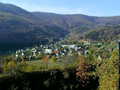
The largest space of water, as many of you are suspecting, is the system of artificial lakes under the sunny Palava hills. Waterworks Nové Mlýny is a system of dams, whose names are the communities on their banks, although sometimes not so literally, as the upper reservoir NM I was named after the village Mušov, which was by building of lakes flooded. It was retained only a small island with a mysterious-looking church. Věstonice and Nové Mlýny tanks create the all complex of interconnected bodies of water, which is an annual attraction for all water sportsmen, fishermen, sailors and especially windsurfers, whose base is in Pasohlávky camp, which is reportedly the largest camp in Central Europe ... The tanks were built near Mikulov in 70years of last century, with their total area of 1668 ha and a depth of about 7 meters are by far the largest water area of Moravia. In a nationwide scale are the fourth behind Lipno, Orlik and Švihov, which are almost 1000 hectares smaller than them.
 The largest Moravian pond is the pond Nesyt, also called Sedlecký pond, which is also an important nesting place for more than 30 species of birds. With the area of 296 ha is the seventh largest in the Czech Republic. One of the Lednice ponds near Lednice-Valtice got its name from one of the water birds - stork tropical genus "Nesyt". The lowest point of Morava is the confluence of rivers Morava and Thaya, the picturesque landscape of forests and ponds, near the Austrian border. Region promised cycling and discovering the beauty of the historic border triangle between the Czech Republic, Slovakia and Austria is also a region with one of the largest floodplain forests in Europe. The whole area Břeclav and its lowest point is then located at an altitude of just 148 m (in comparison Hřensko - 115 meters above the sea).
Finally, the deepest abyss, one of the big attractions, which still has not issued all of its secrets till now, it is Hranická gap with its depth of 70 m dry parts - the lakes and other surface around 170 m depth being explored. So far, the deepest recorded dive depth of the 180 meters, but it is expected that even this number is not final. Geologists speculate about the depth of almost 700 meters! Nearby lies the abyss also Zbrašov aragonite caves that are popular tourist excursion destinations. Hranická gap compared with commercially utilized Macocha has its charm, because you don’t need to a walk on nature trail around the souvenir. The shortest way to get here on foot from the railway station Teplice nad Becvou along the red trail, which is also the tourist circuit in the overall length of less than 5 kilometers - a relatively easy walk suitable for smaller children. By this tip of trip ends our second stop on Top of Moravia, which may be extended continuation, focusing more on the hiking and learning about the localities.
Text: Jan Chaloupka
Photo: archives, wikipedia commons: huhulenik
| Discussion at the article (0) |
Related Articles

Lipno - Czech Sea Full Of Dragons - VIDEO
Do You Know That? The Moravian Best I.

CZ, Blansko – Rocky Mill
Mikulov


Guide:
Important Information:
![]() Information and warnings on travelling abroad is to be found HERE.
Information and warnings on travelling abroad is to be found HERE.
Mobile application:

![]()
![]()


