
SK, Vrsatska Klippe: The Klippe Mohicans – VIDEO

Concretely, these are situated north from the town of Ilava, the Region of Trencin. The point of start is Vrsatske Podhradi village. A blue tourist trail goes from there. A car park is situated right next to the village. Those who prefer rather public transport can get to the rgeion by several bus lines.
")
ore demanding tourists can walk more demanding tourist trails such as the one from Cerveny Kamen. It is of yellow color. The walk takes about an hour. Or you can set off from Bolesov village by following the green marked trail. You should reach your destination in about two hours. As we are quite comfortable persons, we chose the closest access point.

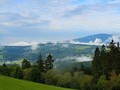
We went downhill and uphill along the Vrsatska klippe nature trail. There were many beautiful vistas and we learned a lot about geology, history, fauna, and flora. We learned that the bedrock consists of a plate composed of limestone, marl, radiolarite, slate, and other rock. We by ourselves we observed paleontological findings such as fossils. We were not so lucky about fauna. At least, we walked through an area where many endemites live. An endemit is a species which lives on a particular place and nowhere else.
")
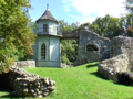
Apart from nature scenery, the remains of a medieval castle caught our attention. It protected the northwestern border of the then Hungary. The castle belonged to the legendary realm of Matus Cak Trenciansky. Later, he was replaced by well-known Hungarian nobleman Stibor ze Stiboric. The fortress had several other owners. In the 17th century, Vrsatsky castle fell into the state of decay. Later it burned down. Explosives destroyed it during the Rakoczi uprising. The result is visible today.


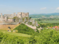
The highest peak of the Vrsatske Klippe is Chmelova klippe (925 m). It is the second highest peak of the White Carpathian mountains. Vrsatec-Javorník klippe (897 m) is another interesting part of the mountains. We enjoyed the vista over the Central Povazi region. We saw the rivers of Ilava, Dubnive nad Vahom and even the Vah. Also, we saw the D1 freeway and the Strazovske Hills rising up behind the freeway.
This circular trip took us three hours. We got everything dear to a true toursit's heart. We will return there gladly on some day. We reco,mend you this relatively easy trek as well.
GPS: 49°03'54.4"N 18°09'08.4"E
Text: Oskár Mažgút
Photos and video: Jozef Dovičin
Music: Dark Memory – Silent Partner
| Discussion at the article (0) |
Related Articles
SK, Dubnica nad Váhom: the heart of the Ilava basin - VIDEO
SK, Trenčín Region – The Kingdom of Matúš Čák II
CZ and SK, White Carpathian Mountains – Velky Lopenik and an Observation Tower on the Summit - VIDEO

SK, Povazska Bystrica: Tourist Trip to the Klapy – VIDEO

SR, Brezova pod Bradlom – A Town of National Pride – VIDEO

SK, Trencianske Teplice – A Unique Spa Town I

SR: The Picturesque Village Of Lednice And Same Named Castle Ruins

SR: Cliffs Of Vršatská – Guards Of Middle Považí

SK, Beckov: Medieval Town in Povazi – VIDEO

SR, Central Považí: National Historic Landmark Castle Of Beckov

SVK: Trenčín And It's Castle Rock

SK: Trencianske Teplice, A Spa Town

SK: Trencin – Matthew’s Kingdom

SK, Nimnica – spas, water, tourism all in one – VIDEO
Related Photogallery

SK: Bezovec Ski Resort

SR, Varsatska Klippe – The Dominant of the Povazi Region
SK, CZ: White Carpathians and Velky Lopenik

SK, Beckov Castle – A Povazi's Landmark

SK, Nimnica – Healthy Relax

SK, Trencin Castle: The Monument of Povazie
Related Videos

SK, Povazska Bystrica – Klapy Nature Reserve

SK, Vrsatska Klippe – The Mohicans of Povazie Region


Guide:
Important Information:
![]() Information and warnings on travelling abroad is to be found HERE.
Information and warnings on travelling abroad is to be found HERE.
Mobile application:

![]()
![]()


