
Zakarpattie Region – Tourism

There are countless options to make a hike. And few tourists will be able to resist this beautiful hilly area, where you can beat several mountains over 2 thousand meters high - Brebeneskul (2034 m), Rebra (2001 m), Gutin - Tomnatik (2016 m.) and Petrosa (2020 m)
Thanks to the volunteer activities of Czech organizations, tourist signs have been improving. While a few years ago you had to rely more simply on your orientative sense, today the Zakarpattia region is interwoven with a number of well-marked hiking trails.

During the First Republic, this area was a very popular destination for tourists. Trail marking was excellent back then. Over time, however, during the Soviet Union, this marking has been destroyed. After the year 1990, it was restored and all tourist routes marked so far are also mapped on Ukrainian tourist maps.
The well-known village of Kolocava, the birthplace of the infamous Nikolas Suhaj, is a favorite starting point for 160 km of local routes. From here you can go to Polonina Krasna or Borzava or go to the lake Sinevir.

You can find plenty of maps on the internet as well. You can prepare your trip in advance. I recommend downloading offline maps to your mobile. Distance and availability are two different concepts and you can extend your route for two days.

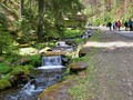
I visited Borzava polonina and I have to say, without the slightest exaggeration, that its beauty almost brought me to tears. From the guest house U Leva (where you can speak with Czech owners) you can go to the waterfalls, take the cable car to the ridge of the polonium and go back.


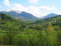
But you do not have to go somewhere far awy. When you wake up in the morning, you can run out of the valley to the nearest hill. As the altitude rises, a fascinating view of Borzavas opens before you. Her Majesty will take your breath away. The highest peak is called Stij (1681 m). On its eastern side, there is the river Borzava.


Borzava is its largest polonina in the area. If you like ridges, you should definitely come out here. The length of the Borzava ridge is about 45 kilometers. Beautiful vistas shall be your reward.
GPS: 48°21'00.3"N 23°00'07.8"E
Text and photos: Michal Hejl
| Discussion at the article (0) |
Related Articles
The Zakarpattia Region – The Lake of Miserable Lovers
Ukraine, Kiev – Ancient Metropolis – VIDEO

The Zakarpattia Region – From As to Jasina is Our Homeland
Zakarpattie Region, Kolocava – Following the Traces of an Outlaw


Guide:
Important Information:
![]() Information and warnings on travelling abroad is to be found HERE.
Information and warnings on travelling abroad is to be found HERE.
Mobile application:

![]()
![]()


