
SK: High Tatras – Climb up to Svinica
Svinica – The Westernmost Edge of the Tatras
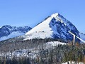
Svinica (Świnica) is a hill, which also, thanks to its convenient location, is often visited by tourists from Poland. It lies directly on the state border between Slovakia and Poland, at the same time it is the westernmost mountain of the mountain range. From the top station of the cable car leading from the Polish side of Tater to Kasprowy Wierch, it is only 3 km away, and is therefore well-accessible for tourists. Svinica is the first significant mountain on the western edge of the High Tatras, which towers up to an altitude of 2,301 meters on the main Tatra ridge like an imposing impressive tower. It is accessible from the Zakopane and Lysa Polana or from Slovakia by crossing the Tichá valley and then the exit to the main Tatra ridge.

From Podbanske Across the Ticha Valley
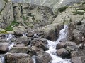
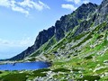
One of the possibilities to get up to Svinice is a variant of the route from the Slovak part of the Tatra Mountains through the Tiche valley. The total length of the trek is 38.13 km, because the major part of the route is the passage through the large, quiet valley. In order to save time, we can use the wheel for a faster lapse of this long stretch of route. Through the quiet valley leads a marked cycling trail running parallel to the yellow hiking trail, which ends at the "Liptovsky Kosar" signpost. Near the junction there is a bridge across the creek, on whose railing we can lean and lock the wheel. We continue on foot along the yellow mark and climb up towards the main Tatra ridge. As we have seen above, the views of the Tiche valley are becoming prettier and more breathtaking. After about 2 hours of climbing, we reach the main ridge of the Western Tatras and enter the Suche Klippe (1 949 m above sea level). Here we will join the red hiking trail and after the ridge our steps will lead us to the peak of the distinctly protruding mountain - Svinice.

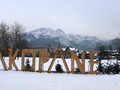
Z polské strany od Zakopaného
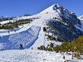
Very popular and fast climb to the peak of Svinice is from Poland. You can easily and comfortably leave the main Tatra ridge by cable car along the route Kuznice - Myslenicka Turnov - Kasprowy Wierch. On the southern outskirts of Zakopane, in Jaszurowka, we pass through Dolina Bystré to Kuźnice, where the lower station of the cable car is located. This will take us to the Myślenickie Turnie (1 360 m above sea level), where we will take the second funicular to the main station of Kasprowy Wierch (1 987 m above sea level). For the more capable tourists, there is the possibility of pedestrian access from Zakopane to Kasprowy Wierch and from there continue on the main ridge to Svinice. Even in this case, we can start the tour in Jaszcurowka, located on the southern outskirts of the city. We cross the Bystré valley towards Kuznice, where we join the green hiking trail. After an approximately 3.5-hour trek, this route will take us to the top of Kasper's Hill.

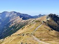
Svinica – Scenic Vista on the Main Tatranian Ridge
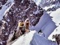
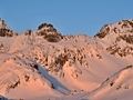
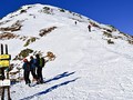
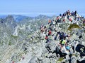
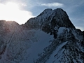
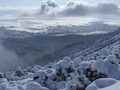
From Suche Klippe, which is located near the Kasper's hill, we follow the red marked path along the rugged ridge of the Western Tatras. Passing through Lili's saddle we head to the Svinicky saddle. We stand in front of the high mountain that is our goal. We climb steeply up the steep alpine terrain, climb the altitude, and the trail turns right. We walk through a few dangerous sections with chains, then rise again, safety on the steep rocky paths allow us again chains. The hiking trail is occasionally exposed, a sure and solid walk is necessary. After several rather difficult passages, we reach the finish point of the tour.

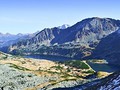
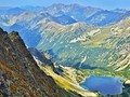
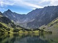
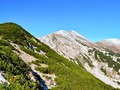
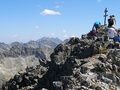
The vistas of Svinica and surroundings the surrounding roots, the hills and valleys of the High and Western Tatras are splendid. On the Polish side of the Tatras, we were especially fascinated by the view to the wide Dolina Pieciu Stawow Polskich. Charming is the view to the north, where the hill Koscielec (2,155 m above sea level) and the Gąsienicowa valley are deeper. In the Slovak part of the Tatra Mountains, the silhouettes of mighty Tatra shields will attract us and in the distance the dominant Krivan (2 494 m above sea level). The most impressive, however, is the view towards the Western Tatras, which lies on our palm. You can see almost the whole mountain range - from the Liptovske Kupy through the vast Ticha valley to the remote hills and ridges of the Western Tatras in the Rohace territory.


GPS: 49°13'10.1"N 20°00'32.6"E
Text and photos: Radoslav Biskupič
| Discussion at the article (0) |
Related Articles
Poland, Zakopane – The Mountains Next Door
SK, High Tatras – Climbing Over the Winter Ridge
SK: Unusual Records of the Tatras and Trnava
SK: High Tatras – To Hladke Klippe Across Koprova Valley
SK: Low Tatras – Autumn Trip Up Kralova Hola
SK, High Tatras: Winter Hikes in Velka Studena Valley
SK: High Tatras – Winter Hike Up Predni Solisko
SK: Western Tatras – Winter Climb to Placlivy
SK: High Tatras – Hiking Up Koprovsky Peak
SK: High Tatras – Hike Up the Popular Peak of Rysy
SK: High Tatras – Climbing to Sedlo pod Ostrvou
SK, High Tatras - Climbing up the Furkotsky Shield
High Tatras: Climb on Velka Svistovka
Related Photogallery
SK, The Tatras – Tichá and Pięciu Stawów Polskich Valleys
SK: Western Tatras – An Autumn Trip up Baranec Mountain
SK: High Tatras – A Trek Up Predni Solisko
SK: High Tatra Mountains – A Trek Across Mlynicka and Furkotska Valleys

SK: Western Tatras – Climbing Up Ostry Rohac
SK, High Tatra - Monumental Krivan Mountain

SK: High Tatras - Ice Beauties
SK: High Tatras - Winter Impressions I


Guide:
Important Information:
![]() Information and warnings on travelling abroad is to be found HERE.
Information and warnings on travelling abroad is to be found HERE.
Mobile application:

![]()
![]()


