en.infoglobe.cz » LOCALITIES

LOCALITIES

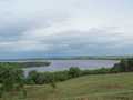
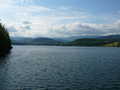
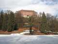
Nechranice
Locality type: Dams
Continent: Europe
State (country): Czech republic
Place: Between towns of Kadań and Chomutov

Nové Butovice
Locality type: In-line Locality
Continent: Europe
State (country): Czech republic
Place: Prague - Nové Butovice

Nové Dvory - Babí
Locality type: Educational path
Continent: Europe
State (country): Czech republic
Place: Trutnov district
Novobystřický circuit
Locality type: Cycling of curve
Continent: Europe
State (country): Czech republic
Place: Jindřichův Hradec district

Novohradský circuit
Locality type: Cycling of curve
Continent: Europe
State (country): Czech republic
Place: České Budějovice district
Novostrašecko
Locality type: Educational path
Continent: Europe
State (country): Czech republic
Place: Rakovník district

Nymburk - island
Locality type: Educational path
Continent: Europe
State (country): Czech republic
Place: Nymburk district
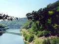
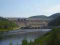
Nýrsko water reservoir
Locality type: Dams
Continent: Europe
State (country): Czech republic
Place: Nýrsko, Klatovy district

Odra - Landek
Locality type: Educational path
Continent: Europe
State (country): Czech republic
Place: Ostrava district

Olšovec pond route
Locality type: In-line Locality
Continent: Europe
State (country): Czech republic
Place: Jedovnice
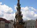
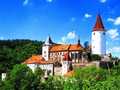
Opočno - castle
Locality type: Castles
Continent: Europe
State (country): Czech republic
Place: Rychnov nad Kněžnou district
Orlík near Humpolec
Locality type: Castles
Continent: Europe
State (country): Czech republic
Place: Pelhřimov district

Osek
Locality type: In-line Locality
Continent: Europe
State (country): Czech republic
Place: Osek, okres Teplice

Osičina Look Out Tower
Locality type: Lookout tower
Continent: Europe
State (country): Czech republic
Place: Rychnov nad Kněžnou

Otrokovice - in line
Locality type: In-line Locality
Continent: Europe
State (country): Czech republic
Place: Otrokovice

Pálava circle
Locality type: Cycling of curve
Continent: Europe
State (country): Czech republic
Place: Břeclav district

Palkovické Hůrky (Palkovické Lofts)
Locality type: Educational path
Continent: Europe
State (country): Czech republic
Place: Frýdek - Místek district

Paradise route (Cesta rájem)
Locality type: Cycling of curve
Continent: Europe
State (country): Czech republic
Place: Semily district
Paraplíčko
Locality type: Educational path
Continent: Europe
State (country): Czech republic
Place: Rakovník district


Localities:

Important Information:
![]() Information and warnings on travelling abroad is to be found HERE.
Information and warnings on travelling abroad is to be found HERE.
Mobile application:

![]()
![]()


