
Following Blaník Knights

Cycling of curve
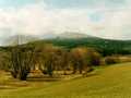
Following Blaník Knights
This route is quite long but not too difficult. Your excursion could be started from the town of Benešov in direction towards the community of Radíkovice. You overcome railway crossing, and on next crossroads, you turn to the left in direction to Skalice and continue ahead, via villages of Pozov, Postupice, Milovanice, Čelivo and Nespery. Further, you pass Veliš and descend towards Ostrov, on bridge over Blanice-river, and consequently, to a road in direction Vlašim - Louňovice.
On this main road, you turn to the right in direction to the community of Louňovice pod Blaníkem, and shortly afterthat, you drive to the left, along a path, mounting up steep of Velký Blaník Hill. You arrive to crossroads, turn to the left along a path, and after next kilometre of drive, your route joins green marked tourist trail, mounting upstairs again, reaching towards a top of Blaník Hill. Would you have a stop here, and mount upstairs on foot (0,8 kms), following red and green marked tourist trails, in direction to Blaník look out tower.
After sightseeing, you descend back down to a path, turn to the right and with quick descent, you are, within couple of minutes, in Louňovice. From here, you mount, following red and yellow marked tourist trail, just to small chapel, and in the village of Libouň, you turn aside to the left, and after Strašice brook, you turn again to the left, in direction to the place of Roudný. Shortly, you arrive into nature park Kaliště-Džbány. Further, you mount, passing Budenín and Kaliště, approaching quickly to Benešov. You drive through communities of Jiřín, Ouběnice and Jinošice, and do not forget to turn aside in Lištěnec, in direction to the town of Bystřice. You drive around Splavský Pond and reach railway station Bystřice u Benešova.
Nearby, a subway is to be found, you pass it, and arrive soon to communities of Semovice and Jírovice. Small section only on a road, then to the left, and again to the right, following the road towards Konopiště Pond, and along its banks, you arrive to Konopiště Castle.
Route length: 65 kms
Character: the route is long, but not of too difficult stage.


Localities:

Important Information:
![]() Information and warnings on travelling abroad is to be found HERE.
Information and warnings on travelling abroad is to be found HERE.
Mobile application:

![]()
![]()


