
Rough Děčínský Sněžník

Cycling of curve
Rough Děčínský Sněžník
Nerby the river: Elbe
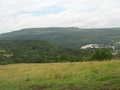
This route can be started direct from streets of Děčín, from Tyrš-bridge below Pastýřská stěna (Shepherd´s Wall). You drive through Červený vrch (Red Hill) quarter and turn to red marked tourist path which leades you - via irregular asphalted road to forest path. This road takes you out up to small village of Sněžník, you pass through, and on crossroad at Hřebenová (Range) Chalet you turn to the right and continue upstairs the hill. After two kilometers of drive, you reach top of Děčínský Sněžník. You find here stony look-out-tower. From this place, there is marvellous view around. On top, there is tourist cottage with restaurant available, so you take with pleasure the advantage of relax here, we are sure. After refreshment, you continue back to community of Sněžník, and in original direction follow long descent (drive down) to community of Maxičky. Here, you turn to the left and reach yellow marked tourist trail, following, after a while, to forest path, which leads you upstairs, downstairs, to the right and to the left. In a moment, when you reach a bank of Dolnožebský Brook, you feel some tension as the way starts to drop sharply (violently) and you have to overcome damped stones which slide. Narrow forest valley leads you to Elbe river, concretely to Dolní Žleb. You have a stop here with pleasure and have relax in local restaurant ?U Kosti?. So, your excursion terminates as from Dolní Žleb, there is a section of very pleasant and romantic way back to Děčín.
Route length: 48 kms
Character: this route is quite difficult, suitable for mountain-bikes
Photo: Wikipedia.com


Localities:

Important Information:
![]() Information and warnings on travelling abroad is to be found HERE.
Information and warnings on travelling abroad is to be found HERE.
Mobile application:

![]()
![]()


