
CZ, The Giant Mountains – Two Different Ways How to Get to Vrbatova Cabin
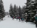
Even not that good snow cover will often allow you to put on alpine skis just a few meters below the hut on Jelení. On this path you will continue up to the slope under the funicular Labská, after which the first and fortunately the last worst steep climb today awaits you.

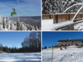
Once you get to the place where the ski slope is intersected by a cross-country ski run (cycle path in summer), take it to the right. After 1.5 km you get to Horni Misecky (ski lift) at a height of 1025 meters. There is a small kiosk with seating and snacks. 
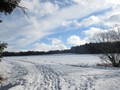
From here, follow the red marked Buchar trail, cross the ski slope and continue past the Jilemnická bouda, just 0.5 km from the kiosk. It is just over 5 kilometers to Vrbatova bouda and it is again a slight climb, but it is not difficult, because you will follow most of the route on a wide cross-country ski trail. After another kilometer of road you will reach the place marked Nad Jilemnickou cabin (1105 meters above sea level), from where you continue only on the red trail. The road is wide and really well marked. With every step ascended, you have stunning views of the surrounding area.


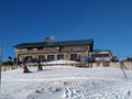
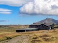
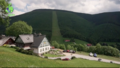
On the mountain of Vrbatova shed you can enjoy refreshments with the possibility to warm up inside and sit in the sun on the deck chairs on the shed terrace. There is a lot of people in nice weather, but the place is always free. The chalet is located at an altitude of 1400 meters and near the stone burrial mound of Hanča and Vrbata. After a rest, you only have to go back.

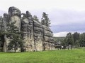
You can also get here by another route. First you will follow the Deer path, which is marked with a green sign. After half a kilometer, a blue sign connects to it from the right, but a few meters further on at a resting place at the sign indicating Labská clone slightly up the hill on the left. After 1.5 km you will pass Harrachova Rock and you will join the Buchar Road again, but just before the SKI area of Horní Mísečky you will join the Krakonoš's Story Nature Trail. Continue again 1.5 kilometers before you reach the ski slope SKI Medvědín. After that you will ascend to its top to a height of 1235 meters. From there, it is one kilometer to the Bear Lookout along the Bear Road, where you will join the Buchar Road again. It will soon connect to the main route leading to Vrbatova shed.


GPS: 50°45'04.9"N 15°32'55.4"E
Text and photos: Veronika Schubertová
| Discussion at the article (0) |
Related Articles
CZ, Brdy: Where to do Cross-Country Skiing?
CZ: 5 Tips for Winter Trips to the Nature – VIDEO
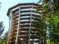
CZ, Giant Mountains – Exceptional Mountain Hotel
CZ, Janske Lazne – Korunami Stromu Nature Trail in the Krkonose Mountains
CZ, Jizerske Mountians – Cross-Country Skis and Semerink's Slopes
CZ, Dětenice – A Chateau, A Brewery and A Medieval Inn
CZ: Spindleruv Mlyn – A Town in the Heart of the Krkonose – VIDEO
Related Photogallery
CZ, Adršpašsko-teplické Rocks and the Museum of Mountain Climbing
CZ, Krkonose Mountains – Korunami Stromu Trail
CZ, Krkonose: Vrchlabi – A Town on the Elbe
Related Videos
CZ: Spindleruv Mlyn – The Town in the Heart of the Krkonose


Guide:
Important Information:
![]() Information and warnings on travelling abroad is to be found HERE.
Information and warnings on travelling abroad is to be found HERE.
Mobile application:

![]()
![]()


