
East Slovakia, Vihorlat I – Into the Wild
The national park of Vihorlat forms the east of the mountain range. The west of the mountain range is currently the military area of Valaskovice, meaning tourists are not allowed to enter. Actually, the maximum time you can spend there is 24 hours. Vihorlat mountain is also the highest summit of the mountain range. It 1075,5 meters tall.

There are no tourist trail within the military area. The only option if you want to cross the mountain is the blue tourist trail which goes from Sninske Ponds across Sninsky Kamen. Then you join the red trail to Remetske Hamry or Podhorod, a town located more eastwards. Another possibility is to join the green tourist trail which goes to Poruby pod Vihorlatom. To finish the trek you need about two days.
When going from Runina to Snina we had planned to spend a night somewhere around Sninske Ponds, a natural pool. Also, there is a camp, closed unfortunately. Eventually, we found out a quiet place next to the road that is accessible to cars with special permission. There we spend the night, quite adventurously.

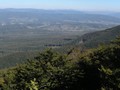
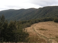
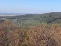
On the following morning a bright and sunny day woke us up. But it was cold. At around 9 o’clock we set off to the first part of our journey. It went along an asphalt road and two hours later we joined a steep forest path. It took us to Sninsky Kamen (1 006 meters above sea level). The sight consists of two outcrops (Velky and Maly Sninsky Kamen ). Atop you have beautiful view of the surroundings. To the north there is Snina and the Bukovske Hills. To the south there is Morske Oko lake. Good weather also allowed us to observe falconiformes flying in circles high above us.

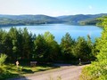
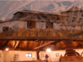
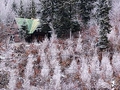
We joined the red tourist trail when we were leaving Sninsky Kamen. The trail led us to Nezabec summit (1 023 meters above sea level). Then we descended along the green trail to Morske Oko. In this section of the trek almost all the time we were going through thick woods. We didn’t enjoy any beautiful view however we enjoyed Morske Oko lake , nobody was around. The landscape reflecting on its calm water surface was breathtaking. No tourists moved around the lake in this season of the year. Therefore, we fully enjoyed silence of nature and its remoteness. Altogether three cottages lined the coast of the lake. Tourists may use two in the summer as accommodation or restaurant.


The lake came to be after a massive landslide from surrounding slopes. The mass blocked the Okno river in the area of the the Vihorlat mountains. Its volcanic activity was decreasing. It was declared a national park which hosts protected fauna and flora. Moreover, the lake is the largest dammed volcanic lake in Slovakia. Its area is 13 hectares and at the deepest is the bed 26 meter below the surface. Six permanent tributaries flows into the lake and couple of irregular. Through the Okno River water outflows from the lake. At Senianske Ponds the river flows into the Cierna Voda River.
We built our tents on the riverbank next to a cottage. After the dinner we hung trash in a bag on the iron fence of the adjacent cottage. We did this to prevent us from having an unintentional visit from bears. In no time we got into warm sleeping bags and looked forward for the following day. We were decided to climb the highest summit of the mountain range. You will learn about the result of our adventure next time.
GPS: 48°54'32.0"N 22°10'05.9"E
Text and photo: Vojtěch Bližňák
| Discussion at the article (0) |
Related Articles
SR, Presov – The Gem of Saris
SK, Mala Trna – Unique Observation Tower
SK, Poloniny National Park – The Most Picturesque Nook in the Country
SK, Kosice – Main Street I
Eastern Slovakia: Solivar - Unique Technical Monument I.
Eastern Slovakia: Solivar - Unique Technical Monument II.
East Slovakia, Bukovske Hills I – Into the Wild
Eastern Slovakia, Vihorlat II – Into the Wild

SK, Kosice – The City of Gold Treasure
SK, Kosice – A Tour of a Museum
Eastern Slovakia, Bukovske Hills III – Into the Wild
Eastern Slovakia – A Visit in Morske Oko and Winetasting
Eastern Slovakia: Šariš Region – Castle of Šariš I.
Eastern Slovakia: Šariš Region - Castle Of Šariš II.
Eastern Slovakia: Drienica – Claim To Lysá Mountain


Guide:
Important Information:
![]() Information and warnings on travelling abroad is to be found HERE.
Information and warnings on travelling abroad is to be found HERE.
Mobile application:

![]()
![]()


