Sierra Madre And Mexican Volcans
Mexico mountains are not too visited, so that, with exception of Popocatepetl, any tourist hinterland is missing. Nevertheless, it could not be judged, if it is advantageous or not, it depends on angle view of tourist´s.
The base of the whole mountain system is formed with two ridges – the west one is known as Sierra Madre Occidental, whereas the east one names Sierra Madre Oriental. Among the towns of Mexico and Veracruz, where both branches are joined in parallel direction, with tectonic breakdown, 1000 kms long and establishing Eje Volcanico, so all the highest Mexican volcanos are to be found there. Sierra Madre Area is divided into five main mountain ranges, such as: Sierra Madre Occidental, Sierra Madre Oriental, Eje Volcanico, Sierra Madre de Sur and Sierra Madre de Guatemala.


Sierra Madre Occidental
This mountain range passes along Pacific Ocean coast. As a rule, it is divided into three groups, such as: Sierra Tarahumara, Sierra Madre and Sierra Nayarit. The highest peak is those of Nevado de Colima (4339 m), the others are Vulcan de Colima (3880 m) and Tancitaro (3845 m).
Sierra Madre Oriental
It gets out of Rio Grande-river with not too high oval ridges, exceeding height level of 3500 metres, such as Cerro Pena Nevada (4054 m).

Eje Volcanico
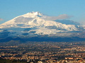
This is most interesting part, and also most visited mountaneous area of Mexico, with the highest volcanos, such as: Pico de Orizaba (Citlaltepetl - Star Mountain - 5700 m), Popocatepetl (Smoking Mountain, 5452 m), Ixtaccihuatl (Sleeping Woman, 5286 m), and Malince (4461 m).
Sierra Madre de Sur
It is south continuation of Sierra Madre Occidental. It is a system of irregular gneiss ridges along Pacific Ocean (Toetepec, 3703 m). This mountain range is passing - in Tehuantepec neck - into Sierra Madre de Guatemala.
Sierra Madre de Guatemala
Tajumulco (4210 m) is the highest peak. On the other hand, active volcano of Pacala (2552 m) is most visited place. Consequently, this mountain range comes into Central-American Cordillera Mountain Range.


The Climate
In Sierra Madre, three climate belts are dominating: mountain belt - up to the altitude of 650 metres above sea level. Here quite big precipitation and tropical vegetace prevail. Moderate belt (650 - 1800 m): the climate is subtropical, the forests are consisted of pines, oaks and big number of subtropical useful plants. And finally: cold belt (1800-3000 m): scarse precipitations and big temperature differences between day and night.
Waters
As far as water flows is concerned, the area of Mexican mountains is rather poor. The supply with drinking water belongs to one of greatest problems of this countryside (not only in the mountains, but also in great towns´ complexes). The belt of eternal snow begins in an altitude of 4700-5000 metres above sea level, whereas with snow covered mountain peaks present an important place in Indian´s mythology. So, Popocatepetl and Ixtaccihuatl, for instance, are covered with glaciers of the extention of several square kilometres.
Nature
 Till now, the original mountain vegetace is preserved in places, unsuitable for agricultural use, i.e. in heights exceeding 3000 metres or on violet slopes. As dominant wood sorts, these are, for instance, Mexican fir-woods or Hartweg pines. In an altitude of four thousands metres above sea level, there is to be found vegetace of Alp stage, and two wood sorts are available, such as: juniper-trees.
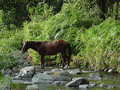
As far as the fauna is concerned, it is quite scarse. To threatened sorts belongs lava-rabbit and small leguans. Nevertheless, butterfly monarch migratory is one of most interesting animals- insects.
Population
Mexico inland is inhabitated very densily. Here, you can find Ciudad de Mexico, one of the biggest towns of the world. The town has approx. 25 millions of persons and t is only 50 kms distant from volcanos of Popocatepetl and Ixtaccihuatl. Anyway, most of total population is presented by cross-breeds of Indians and whites, which form approx. 60% from total population. Pure Indian tribes are living in south only, in Lacatun virgin forests.
Text: J. Štantejský
Photo: Panoramio.com - EDUARDO MAYA, rmartine, Angel Miranda, Hans Hartings, Carlos Cruz C, noelpp, pepeleyva, francisco lopez p, paty_lopez_hidalgo, andres diaz mx, luisdia
| Discussion at the article (0) |
Related Articles
Do you know, that…? The Volcano II.

Mexico, Monterrey: The modern center of the country


Guide:
Important Information:
![]() Information and warnings on travelling abroad is to be found HERE.
Information and warnings on travelling abroad is to be found HERE.
Mobile application:

![]()
![]()