
Žďárské Vrchy (Hills) - Czech republic
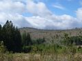
Žďárské Hills form part of Bohemian-Moravian Highlands, situated on border of Bohemia and Moravia. Its highest point is Devět skal (Nine Rocks) of 836 m height. The hills are extended on the territory where were passing many important business trails.
The mining of silver (from 14th up to 18th century) started very important period of this region. As to monuments - most important is those of Church dedicated to St. Johann Nepomuk in Zelená Hora.
In 1970 the hills were declared as Protected Natural Area.
Natural Area of Žďárské Hills was formed on a surface of 715 km2 on 25th May 1970.
One part (465 km2) is situated on the area of Žďár nad Sázavou district and the rest
(250 km2) on the area of Havlíčkův Brod, Chrudim and Svitavy. The boundary of this protected area form appr. four-corner. The highest is Malínská skála (812 m).
| Lokalities Subjects | Articles Photogalery | Videogallery Discussion |
Lokalities
From Nové Město Around Paseka And Pohledec Rocks
Cycling of curve
Žďár nad Sázavou district

Žďár nad Sázavou - Pilská nádrž (Pilská basin)
In-line Locality
Žďár nad Sázavou, Polička


Mountains / Europe / Czech republic

Important Information:
![]() Information and warnings on travelling abroad is to be found HERE.
Information and warnings on travelling abroad is to be found HERE.
Mobile application:

![]()
![]()


