
Cierna Hora Hill Range - Slovakia
Site:
Čierna Hora Hill Range is situated in East Slovakia, in Regions Prešov and Košice, in Gelnica, Košice and Prešov districts. The complex belongs to Slovak Ore Mountains, which forms a part of Internal West Carpathian Mountains.
Extent:
254 square kilometres
The highest hill:
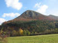
Rohačka – 1028 metres above sea level.
| Lokalities Subjects | Articles Photogalery | Videogallery Discussion |
Short characteristics:
Čierna Hora (Black Hill) is created with Primary and Secondary rocks, such as: slates, limestones, dolomites, but also paleogene conglomerats or crystalic slates. The mineral stone has variegated and hilly relief, where the plains are dominating, with its rocky formations, placed on more resistant mineral rocks. Mountain ridge passage Rohačka belongs to extraordinary beautiful, but not too difficult walking routes, where you can find the highest peak of the mountain range, of the same name. Hornád-river, including its tributaries, takes the water from mountain range.
In west part of the range, the artificial water basin - dam Ružín was built. The reservoir serves as a source of useful water for the industry and warm energy. Its water energy is being used in the same way, and last but not least, the water reservoir serves also for relax. Čierna hora belongs to moderately warm, in its top sections, to cold climatic area.
The surface is covered with forests, pasture lands and arable soil. Regarding forests: leafy wood, mainla beech-wood forests prevail, in its higher situated, north part, pine-trees and mixed forests dominate.


Mountains / Europe / Slovakia

Important Information:
![]() Information and warnings on travelling abroad is to be found HERE.
Information and warnings on travelling abroad is to be found HERE.
Mobile application:

![]()
![]()


