
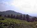
Malé Karpaty (Small Carpathian Mountains) - Slovakia
Extent: 820 square kilometres.
This mountain range is located in west part of Slovakia and divide - similarly as fortification - Záhorská plainland from Danube plainland. The complex belongs to Fatra-Tatra area, which forms a part of West Carpathian Mountains. It is divided into four next parts, such as: Devínské, Pezinské, Brezovské and Čachtické.
Highest peak: Záruby (768 m).
Surface: afforested, including beech-wood and oak forests.
Climatic area: rather warm, in higher localities moderately warm area.
The territory was declared as Preserved Countryside Area in 1976.
| Lokalities Subjects | Articles Photogalery | Videogallery Discussion |
Articles
SK, Vysomarch: A Bike-Bridge Bridging Nations – VIDEO
If we look at the historical records, the memory of bridging the Moravia river near the village of Marchegg dates back to the 13th century. In the past, the connection of both banks was also ensured by a ferry, which last sailed in 1918. Since then, crossing the border river was highly undesirable and cross-border relations were below freezing. Fortunately, after the fall of the totalitarian regime, relations between Slovakia and Austria began to improve significantly, but the two countries were still divided by the Morava River. It took many decades for that to change.


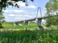
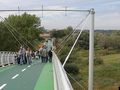
The first road bridge connecting the two nations was not opened until 2005, between Moravian St. John and Hohenau. In 2012, the county Cyklomost slobody was added, which connects Devínska Nová Ves with the picturesque Austrian castle complex Schloss Hof. Finally, after many years of efforts, the construction of a cycle bridge over the Morava River between Vysoká near Moravia and Marchegg began in the autumn of 2020.


The connection between Austria and the village of Vysoká pri Morave was thus renewed after more than a hundred years. The new Vysomarch Bridge connected the Eurovelo 13 international cycle route with the Austrian Kamp-Thaya-March national cycle route. The historic connection between the two halves of the bridge structure took place on October 19, 2021 and was completed during the spring of 2022.

Bike Trip
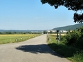
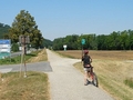
If you would like to visit the cycle bridge between Vysoká pri Morave and the Austrian town of Marchegg, the ideal way is to use a bicycle. We recommend setting off from the Cyklomosta slobody in Devínská Nová Ves, next to which a cycle path leads to the new Vysomarch bridge. It is a 12 kilometer long and relatively flat route with pleasant surroundings. A slightly shorter (7 km) cycle route leads from the village of Vysoká pri Morave. Perhaps the closest connection to the bridge is a cycle path from the Austrian side, directly from the village of Marchegg, less than 1 kilometer.


For less able hikers, we offer the possibility of visiting the bridge in combination, by train from Bratislava to the Marchegg railway station and from there either on your own or for a fee on a rented bicycle. Rental service is available in the parking lot in front of the station. Of course, it is also possible to walk to the bridge!


On the way to the bike bridge you will observe a number of unique nooks, beautiful nature and you will be accompanied by a pleasant bird chirping. There will be flying butterflies, which are given increased attention in Marchegg in the form of a separate nature trail.


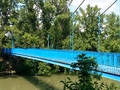
The surroundings of the Vysomarch Bridge are completed by meadows full of flowers and floodplain landscape. In terms of construction, it is a remarkable architectural work with a length of 270 meters and a width of 4 meters. The bridge itself is 7 meters above the average river level and the structure is suspended on steel pillars. The maximum height of the pillars is 17 meters. The bridge has an asphalt surface, safety railings and several information boards on both sides.


")
In the middle of exceptionally beautiful nature, a connection was created between two villages, two nations and states, which connects the lower Záhorie with the Austrian Marchfeld (Moravian Field) and offers excursion circuits in the cross-border area of the unique natural scenery of Pomerania. Together with the second county Cyklomostom slobody, it creates a 22-kilometer-long circuit through floodplain forests, which even families with children can complete. Just go out and get to know your surroundings!

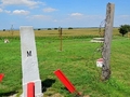
GPS: 48°16'46.3"N 16°55'03.5"E
Text, photos, and video: Pavol Jemala, Slovensko zdola
Music: Pixabay.com; Sedative - 110241
Related Articles
Austria, Wolfsthal: Town on Borderline – VIDEO
Austria, Marchegg: Interesting History, Nature, and Tourism - VIDEO
Bike Trip: Hainburg - Schloss Hof
Biketrip: Deutsch Jahrndorf - Trojmezi
Bike Trip: Petrzalka - Wolfsthal
Bike Trip: Petrzalka – Mosonmagyaróvár
Bike Trip: Rajka - Petrzalka
Bike Trip: Schloss Hof - Bratislava
Slovakia: Book from Around Slovakia Edition – The Most Beautiful Bike Trails, Bratislava and Around
Slovakia, Bratislava: Cycling Bridge Of Freedom
SK, Bike Trip: Petrzalka – The Memorial of M. R. Stefanik I.
SK, Čáry: A Village in Záhorie – VIDEO
SK, Zahorie Region: Adamovska Lakes – Favorite Region for Cottagers and Oasis of Thousands Water Birds
SR, Záhorie: Kunovská Dam - Summer Comfort
SK, Záhorská Ves: A Visit to the Westernmost Town – VIDEO


Mountains / Europe / Slovakia

Important Information:
![]() Information and warnings on travelling abroad is to be found HERE.
Information and warnings on travelling abroad is to be found HERE.
Mobile application:

![]()
![]()


