
Malé Karpaty (Small Carpathian Mountains) - Slovakia
Extent: 820 square kilometres.
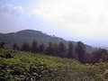
This mountain range is located in west part of Slovakia and divide - similarly as fortification - Záhorská plainland from Danube plainland. The complex belongs to Fatra-Tatra area, which forms a part of West Carpathian Mountains. It is divided into four next parts, such as: Devínské, Pezinské, Brezovské and Čachtické.
Highest peak: Záruby (768 m).
Surface: afforested, including beech-wood and oak forests.
Climatic area: rather warm, in higher localities moderately warm area.
The territory was declared as Preserved Countryside Area in 1976.
| Lokalities Subjects | Articles Photogalery | Videogallery Discussion |
Lokalities

Small Carpathian cycloroute
Cycling of curve
This route is to be started in the community of Vysoká při Morave. In Zohor, the line crosses Záhorska cycling route and comes towards Lozorno. You continue via communities of Jablonové, Pernek, Kuchyňa, Rohožník and Sološnica up to Plavecke Podhradie. Your route leads through Plavecky Peter and Bokova up to the community of Trsín. Further, you continue to Dechtice (here, you can turn away to Dobrá Voda Castle). From here, you drive to the community of Vrbové. Here, you can visit monument house of Moric Beňovsky. Your next driving points will be the communities of Krakovany, Očkov, Podolí and Částkovice, and you reach the village of Čachtice. Here, you can visit local museum, placed in a church or castle ruins.
Route length: 128 kms
Character: this route has middle stage difficulty


Mountains / Europe / Slovakia

Important Information:
![]() Information and warnings on travelling abroad is to be found HERE.
Information and warnings on travelling abroad is to be found HERE.
Mobile application:

![]()
![]()


