
Oravská Magura - Slovakia

Extent: 176 km²
This sandstone mountain range is located in north-west part of Slovakia in districts of Námestovo, Tvrdošín and Dolný Kubín. It belongs to Central Beskydy Mountails, forming part of West Carpathian Mountain Range.
Highest peak: Minčol (1392 m).
Surface: very afforested, mostly with fir-wood and beech-wood forests, partially with pine-woods. In upper localities, there are appearing overgrowns of blueberries and meadow plants.
From climatic point of view, the area belongs to colder belt, characterictic with cold winters and hard rains.
| Lokalities Subjects | Articles Photogalery | Videogallery Discussion |
Photogalery
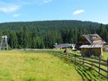
SK, Orava – The Road to the Highest Summit
In our photogallery, we take you to the highest peak of the Oravska Magura – Mincol (1 394 m). We start at Vasilovska Hole near the village of Hrustin. Once we reach its peak we continue down the meadow till we reach forest. Forest paths take us up the ridge where Kubinska Hole, the highest summit of Oravska Magura, is situated. It is mostly known for a ski resort there which is located above the town of Dolny Kubin. Then we need to cross a short distance to reach Mincol and on our way we visit Puchmajer Lake.
Text and photos: Oskár Mažgút
 |  |  |
 |  |  |
 |  |  |


Mountains / Europe / Slovakia

Important Information:
![]() Information and warnings on travelling abroad is to be found HERE.
Information and warnings on travelling abroad is to be found HERE.
Mobile application:

![]()
![]()


