
Poloniny - Slovakia

Extent: 378 square kilometres
This mountain range, known also as Bukovske Hills, is located in northeast edge of Slovakia, on borders with Poland and Ucraine, in district of Snina. It belongs to East Carpathian Mountains area.
Highest peak: Kremenec (1221 m).
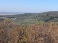
Surface: is afforested or even covered with virgin forests. There are to be found here mostly beech-woods, in places where the trees are missing, there are meadows, glades and fields.
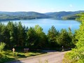
This mountaneous territory is scarcely populated, nevertheless, its nature and fauna are untouched with civilization. In Poloniny area, there is to be found the greatest basin of drinking water in Slovakia - water reservoir Starina.
Poloniny was declared as National Park in 1997.
| Lokalities Subjects | Articles Photogalery | Videogallery Discussion |
Articles
SK, Poloniny National Park – The Most Picturesque Nook in the Country
Eastern Slovakia, Vihorlat II – Into the Wild


Mountains / Europe / Slovakia

Important Information:
![]() Information and warnings on travelling abroad is to be found HERE.
Information and warnings on travelling abroad is to be found HERE.
Mobile application:

![]()
![]()


