
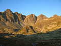
Vysoké Tatry (High Tatra) - Slovakia
Extent: 74111 ha
In north part of Slovakia, along borders with Poland, in districts of Kežmarok, Liptovský Mikuláš, Poprad and Tvrdošín, there is situated mountain range of special character – High Tatra. It belongs, together with Belianske Tatra, to complex of East Tatra Mountains.
Highest peak: Gerlachovka (2655 m).
Surface: it is formed with dense forests, pine woods. In higher sites, there are to be found dwarfish pine woods, plough-tails and lichens. Alp-meadows are located in places where the trees are missing.
Climate: mostly cold, 0 Celsius degrees. The snow remains on surface nearly all year round, on some places does not thaw at all.
Mountain nucleus is formed with granites and crystalic slates, on surface with limestones and sandstones, with appearance of quartz.
Mountain relief is very rough, including steep shields and combs.
We find here caves with karst appearances, waterfalls, lakes (plesa), healing springs, rare plants and many animals, in form of great mammalia.
High Tatra Mountains were declared as Tatra National Park in 1948. Later, in 1993, declared as biospherical reservation within scope of international UNESCO programme.
| Lokalities Subjects | Articles Photogalery | Videogallery Discussion |
Articles
SK, Dovalovo – Urban District of Liptovsky Hradok Worth Visiting
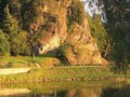
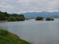
The unbound Tatranian river of Belá flows through the former independent village with its left side tributary, the Dovalovec stream. Excellent transport accessibility is provided by buses, but also the presence of the D1 motorway.


The highway itself forms an inseparable panorama of the city district. On its edge stretches over half a kilometer long highway bridge Dovalovec, which ranks among the longest road bridges in Slovakia, but also a slightly shorter bridge Bela (about 300 m).

From the very beginning, Dovalovo was a serf settlement formed by the Liptov-Hradok estate. In the past, Liptovská Kokava (then Nové Dovalovo) was a part of the village. The original population was engaged in livestock breeding, weighing wood from the surrounding forests and, of course, agriculture. Crafts were also developing, even the Doval Bricklayers were the first in the county to start building brick houses instead of traditional wooden ones. Unusual is also the local dialect and pseudonyms indicating individual parts of the village.

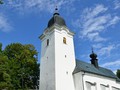
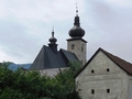
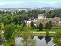
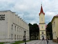
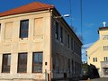
And now we will go to the sights! The most precious is the Gothic Roman Catholic Church of St. Martin of Tours (this saint has the city district depicted in the coat of arms) from the 13th century. The single-nave building with a tower, fortifications and beautiful murals is situated on a hill in the middle of the former village. A little further stands the Evangelical Church from 1673, which was rebuilt and fortified in the 17th century and baroqueized in the 18th century. The late Gothic winged altar of St. Martin bishop and st. Stephen the First Martyr, who became a collection jewel of the Slovak National Museum in Martin. Another medieval inventory of the church was taken to Budapest, so today's classicist building offers much younger works of art by the famous painter Peter Michal Bohúň.

n the once independent village you would also find several important historical buildings, such as a valuable historical core with an interesting urban structure in the part Vyšný konec, Chapel of St. John of Nepomuk, monument to fallen citizens in the I. and II. World War II with unique decoration (Slovak double cross) or birth house of a famous intellectual with Slovak national interests, founder of the Slovak newspaper and prominent builder Ján Nepomuk Bobula.

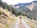
There is also Gašperík's villa with a garden gazebo, Peninist's House, a chapel above Dovalov from 1862, reminiscent of a tragic event when a shepherd with oxen was killed in a storm (also a symbol of an old trade route from Liptov to Spiš). used for storing crops. The natural beauty of the city offers several hiking tours to the surrounding national parks.

And in a week we will end our visit to Liptov region in Liptovský Hrádok.
GPS: 49°02'57.1"N 19°45'32.9"E
Text: Oskár Mažgút
Photos: HIK, o.z.
Related Articles
SK, Liptovsky Hradok – Lesser Known Tourist Spots
SK, Bešeňová – A Village in Liptov With Close Ties to Water
SK, Liptovsky Jan – Extraordinary Town in the Liptov Region
SK, Liptov – Havranok Open Air Archeological Museum and a Solitary Tower
SK, Liptov: Kvacianska Valley and Oblazy Water Mills - VIDEO

SK, Liptov: The Town of Ziar and A Hike into the Surroundings
SK, Liptovská Anna – Tourist Trek up Čerenova Rock
SK, Liptovsky Hradok – Small Yet Beautiful Town
SK, Liptovský Ján – A Bike Trip to Javorie Klippe

SK, Liptovsky Mikulas – The Town of Olympic Winners and More I
SK, Liptovsky Mikulas – Sightseeing
SK, Liptovsky Mikulas – Namesti Zadosti Slovenskeho Naroda Square
SK, Liptovský Peter and Jamník – Traditional Townships of Liptov
SK, Liptov Region – A Summer Full of Experiences
SK, Liptov Region: Stanisovska Cave – Unique Experience for the Whole Family


Mountains / Europe / Slovakia

Important Information:
![]() Information and warnings on travelling abroad is to be found HERE.
Information and warnings on travelling abroad is to be found HERE.
Mobile application:

![]()
![]()


