
Vysoké Tatry (High Tatra) - Slovakia
Extent: 74111 ha
In north part of Slovakia, along borders with Poland, in districts of Kežmarok, Liptovský Mikuláš, Poprad and Tvrdošín, there is situated mountain range of special character – High Tatra. It belongs, together with Belianske Tatra, to complex of East Tatra Mountains.
Highest peak: Gerlachovka (2655 m).
Surface: it is formed with dense forests, pine woods. In higher sites, there are to be found dwarfish pine woods, plough-tails and lichens. Alp-meadows are located in places where the trees are missing.
Climate: mostly cold, 0 Celsius degrees. The snow remains on surface nearly all year round, on some places does not thaw at all.
Mountain nucleus is formed with granites and crystalic slates, on surface with limestones and sandstones, with appearance of quartz.
Mountain relief is very rough, including steep shields and combs.
We find here caves with karst appearances, waterfalls, lakes (plesa), healing springs, rare plants and many animals, in form of great mammalia.
High Tatra Mountains were declared as Tatra National Park in 1948. Later, in 1993, declared as biospherical reservation within scope of international UNESCO programme.
| Lokalities Subjects | Articles Photogalery | Videogallery Discussion |
Photogalery
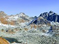
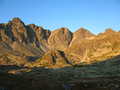
SK: High Tatras – Across Koprova Valley up the Main Ridge of the Tatras
The Koprova Valley is an important valley in the Tatras, through which run the boundaries between the West and the High Tatras. On the left are the hills of the Liptovske Kopy, which form the eastern edge of the Western Tatras. The right side already belongs to the High Tatras. We can begin a very nice all day tour either at the "former Vazecka cabin " signpost or from the Three Wells and following the crossing through the red path through the small crest. We will join the blue trail leading us to the "Hlinska Valley, estuary" signpost. Next continue along the green marked trail leading through the picturesque Kobyli valley to Zavory klippe (1 877 m above sea level). From there, we head down the red marked trail directly into Hladke klippe (1 993 m above sea level), which extends on the main ridge of the High Tatras. The views of the Ticha Valley and the Liptovské kopy, as well as the Polish part of the Tatra Mountains - the magical valley of Piecie Stawow Polskich and the mighty Svinica (2 301 m) and Kozi Wierch (2 291 m above sea level).
Text and photos: Radoslav Biskupič
 |  |  |
 |  |  |
 |  |  |


Mountains / Europe / Slovakia

Important Information:
![]() Information and warnings on travelling abroad is to be found HERE.
Information and warnings on travelling abroad is to be found HERE.
Mobile application:

![]()
![]()


