
Vysoké Tatry (High Tatra) - Slovakia
Extent: 74111 ha
In north part of Slovakia, along borders with Poland, in districts of Kežmarok, Liptovský Mikuláš, Poprad and Tvrdošín, there is situated mountain range of special character – High Tatra. It belongs, together with Belianske Tatra, to complex of East Tatra Mountains.
Highest peak: Gerlachovka (2655 m).
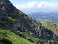
Surface: it is formed with dense forests, pine woods. In higher sites, there are to be found dwarfish pine woods, plough-tails and lichens. Alp-meadows are located in places where the trees are missing.
Climate: mostly cold, 0 Celsius degrees. The snow remains on surface nearly all year round, on some places does not thaw at all.
Mountain nucleus is formed with granites and crystalic slates, on surface with limestones and sandstones, with appearance of quartz.
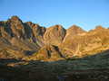
Mountain relief is very rough, including steep shields and combs.
We find here caves with karst appearances, waterfalls, lakes (plesa), healing springs, rare plants and many animals, in form of great mammalia.
High Tatra Mountains were declared as Tatra National Park in 1948. Later, in 1993, declared as biospherical reservation within scope of international UNESCO programme.
| Lokalities Subjects | Articles Photogalery | Videogallery Discussion |
Photogalery
SK, High Tatras – Kriváň Gold and Guerilla Fighters
Today we invite you to a trip to the High Tatras to the majestic peak Krivan, which has been a symbol of Slovakia for decades. However, this time we will not focus on tourism, but on exploring its hidden beauties and sights. The first is a guerrilla bunker, where the fight of German fascists took place with partisan troops of the High Tatras. This memorable place can be reached from the Three Wells tourist crossroads and leads along a green-marked hiking trail to the top of Kriváň. The marked branch to the bunker is located in the first third of the ascent, below the Grúnik hill.
The second unusual stop will be the Kriváňské doly, where gold, silver and other minerals were mined. Though not many of them were found, but even a few were enough to lend Krivan beautiful legends. You will find the remains below the very top of the shield, as well as in the lower altitudes. Their exact location can be found on the map in the Slovak Museum of Nature Conservation and Caving in Liptovský Mikuláš or here. Please note that access to mines is only permitted with authorized personnel.
Dnes vás zveme na vysokotatranský výlet k majestátnímu štítu Kriváň, který je již desetiletí symbolem Slovenska. Avšak tentokrát se nezaměříme na turistiku, ale na poznávání jeho skrytých krás a pozoruhodností. První z nich je partyzánský bunkr, kde se odehrál boj německých fašistů s příslušníky partyzánského oddílu Vysoké Tatry. K tomuto památnému místu dojdete z turistického rozcestí Tři studánky a vede po zeleně značeném turistické stezce na vrchol Kriváně. Značená odbočka k bunkru se nachází v první třetině výstupu, pod vrchem Grúnik.
Druhým nevšedním zastavením budou Kriváňské doly, kde se těžilo zlato, stříbro a jiné minerály. Nenašlo se jich sice mnoho, ale i to málo stačilo k opředení Kriváně nádhernými legendami. Pozůstatky dolů najdete pod samotným vrcholem štítu, jakož i v nižších polohách. Jejich přesnější umístění najdete na mapě ve Slovenském muzeu ochrany přírody a jeskyňářství v Liptovském Mikuláši nebo zde. Upozorňujeme, že přístup k dolům je povolen jen s oprávněnou osobou.
Text: Oskár Mažgút
Foto: HIK, o. z.
 |  |  |
 | ") |  |
 |  | ") |


")
")
")


")


Mountains / Europe / Slovakia

Important Information:
![]() Information and warnings on travelling abroad is to be found HERE.
Information and warnings on travelling abroad is to be found HERE.
Mobile application:

![]()
![]()


