
CZ: Volary - A Gate To Bohemian Forest
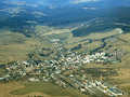
 So, Volary is placed in Prachatice district, South Bohemia Region. The community is located inside the territory of Bohemian Forest Protected Countryside, at the border of Bohemia Forest National Park. The town has 4085 inhabitants (2005).
Short History
The first written notice about the town appeared in 1359, in connection with a survey of Prachatice town-councillor members, mentioning Andrew of Volary. Within 13th and 14th centuries, Bohemia Forest colonization, mostly by Germans from Bavaria, was effected. So, the town of Volary (Wallern in German language) was established there.
Since 10th century, this locality was founded, as a community along old merchant way from Bavaria to Bohemia. The path had consequently several branches where various types of goods were transported. Transfer of salt from Passau via Volary up to Prachatice was effected during most famous period.
Till Hussite War time period, Volary was in possession of Vyšehrad Chapter. Since 1503, Rosenberg Parentage became town owners, followed by Emperor Rudolph II after 1600, and since 1719 by Schwarzenberg Parentage.
Volary served as rest place for beasts of burden who transferred the goods along so called  „Golden Path“. This way of transport became main source of income for the town. Anyway, within main boom, i.e.16th century, in Volary could be registered totally 13 inn-keepers, 4 black-smiths and many beasts of burden families lived there.
During Hussite Wars, even several families of Bohemian origin lived there. Nevertheless, in the course of 17th century, within Estates Riots, followed by 30-Years War, several strong fights were effected in the environs, Estates´ troops as well as Emperors´ troops attacked the town. Finally, the war was terminated with conclusion of so called Westphalia Peace Treaty.
During 16th century, German cattle-breeders settled in Volary. They kept the cattle there according to Alps´ model. So, they brought their characteristic features into Bohemia Forest, presented in architecture, dressing and habits. They constructed wooden carpentered houses, characteristic with their concentration of inhabitated as well as agricultural rooms into one  complex, under one roof. The buildings were storeyed, including stone or partially stone groundfloor and attic rooms, carved railings and carpentered storey (floor). However, only a few of such unique buildings were preserved till now. In one building, you can find Volary local museum. In 1871, Emperor Frank Joseph I. granted Volary town´s status.
At present, a part of the town forms protected monument zone. Old town with such types of houses in Alp´s style of carpentered architecture was declared as monument reservation, and you can find it only in Volary or in the community of Dobrá.
What you cannot miss in Volary and in its environs?
It is, first of all, St. Catherine Church of Baroque style, constructed within 1669-1690, on place of original church of late Gothic style. In 18th century, the church was hardly damaged by lightningts several times which caused big fires. So, essential reconstructions were effected there during 1757 and 1863.
In the environs, you can find Boubín (1362 m). At its foot, Boubín Virgin Forest (on extent of 666 ha) is spreaded. Here, the trees of 300-400 years of age are to be found. Nature reservation was declared there in 1858.
 Huss Castle was constructed in 1341. It is situated inside Blanice-river Valley, on rocky headland, as a protection of Golden Path. When the Hussite Wars were over, the castle was used as a seat by plundering knights. They got their movable property, under leadership of Habart Lopata from Hrádek, in such way that they attacked the merchants who transferred the goods along Golden Path. Habart was declared, as a result of his activity, as „country offender“ and was besieged by region troops in 1441. All knights-robbers were very hungry and were forced, after certain time-period, to give up. And consequently, the castle was burned out andcompletely demolished. So, rather big castle in past, was preserved in a form of demolished rests of fortifications and a part of palace, till now. Just close to the castle, non-karst cave could be found in rocky wall.
The community of Černý Kříž (Black Cross) is placed at slopes of Stožec Hill, at mouth of Hučina-torrent into Studená Vltava-river. The village got its name according to big stone cross, erected on memory of Prince Schwarzenberg, forester, killed (shot) by poacher. Not far from there, you can find Mrtvý luh, nature reservation, which forms a part of Bohermia Forest  National Park It is extensive peat-bog area (394 ha) overgrown with pine-trees and rare peaty plants. Preserved and protected animals are living there, too. Inside peat-bog, you can admire so called „dead forest“. These are dead trees, destructed by big fire.
Bears´ Path was created there in 1967, and it belongs to the oldest path in Bohemia Forest. It leads from Ovesná railway stop up to Černý Kříž, not far from Lipno Dam. Along the path, you can follow many interesting formations, such as: Barenstein - memory place, where the last Bohemia Forest bear was shot in 1856, Schwarzenberg Canal, rocky outlook to Perník Hill slope, Smugglers´ Cave - it is rocky formation, reminding a cave, etc.
Schwarzenberg Canal is a monument of historical importance, constructed within 1789-1822, in acordance with the project of J. Rosenauer, forest ingenieur of Schwarzenberg Dominion. This navigation canal joined Vltava river - basin with Danube river - basin. When the construction was terminated, the canal served for supply of Vienna with combustible as well as construction wood from Bohemia Forest area. The canal is 51 kilometres long.
Text: Maxim Kucer
photo: Wikipedia.org, Manfred E. Fritsche - foto 1, foto 2; Rudolf Bruner-Dvořák, Donald Judge, Ivo Lukačovič
| Discussion at the article (0) |
Related Articles
Prachatice

Lipno - Czech Sea Full Of Dragons - VIDEO
CZ, Sumava: Antygl – Turner’s Cottage- Cenkova Pila


Guide:
Important Information:
![]() Information and warnings on travelling abroad is to be found HERE.
Information and warnings on travelling abroad is to be found HERE.
Mobile application:

![]()
![]()


