
SR: Velký Javorník (Great Javornik)

In northeast, Velký Javorník passes in Butorky Col (982 m), in southeast, there is afforested Ustrigel Hill (1009 m) as its neighbour, in southwest it borders with Stratenec Hill (1055 m) inside its main mountain range. In one kilometer distance in northwest direction, there is passing Slovak-Czech state border. Nevertheless, the crown of each mountain range, there is always its highest peak, Velký Javorník is in this case. It is true that this hill does not belong to important Carpathian Mountains but, no doubt, its position and height is worth for each visitor to climb up to its top. So, do not miss Velký Javorník, during your walking throughout Slovakia!

The name of this mountains has probably cohesion with maple cops (these trees were here planted in past mostly). Javorníky Mountains belong to the area of Slovak-Moravian Carpathian Mountains, Outer Western Carpathian Mountains. In north, the hills border with Turzovka Highlands, on east with Kysuca Beskydes, Žilina-basin (plainland), Sulov Hills and Váh-Valley, on the other hand, in south, there are formed with White Carpathian Mountains, whereas on west, the hills form the frontier with Czech Republic. The country, surrounding Velký Javorník, is formed with minerals, sandstones, decayed plainlands and furrows. The actual face of surrounding countryside is a result of Tertiary formation of tectonic movements along breakages and activities of water flows, decay and slope Tertiary formation processes. These processes of countryside formation are being effected permanently all the time.
Velký Javorník range is surrounded, except small area, with forests. Sandstone peak is overgrown mostly with plants and grass. Velký Javorník (0,44 square kilometres) is national nature reservation, declared in 1967. It is a rest of original fir-wood and oak virgin forests with mixture of pines. To other interesting representants of local flora belongs, first of all, Turk´s cap. The peak of Velký Javorník is crossing educational path Javorníky-Friendship (Družba). This route is 25 kms long with exceeding of 211 m. Necessary information is to be found on seven information tables.
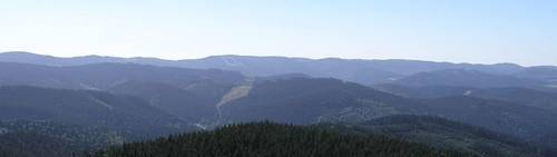
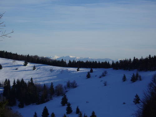
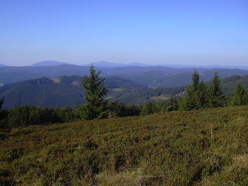
Most often used starting point of all tours up to Velký Javorník, there are places, such as Podjavorník, Raztoky and Horna Marikova. Nevertheless, the shortest mounting starts from Papradno Valley. It leads from the community of Podjavornik (there is parking place available). The mounting, following yellow marked tourist trail up to main range, takes 1 hour approximately. From here, you can continue, following red marked path, reaching the top. Rather longer climbing, there is those from the community of Horna Marikova. The route follows yellow marked path via Sikovce, from here continues up to Orgonova Kyčera Col. Blue marked tourist trail leads you to Malý Javorník (Small Javorník). And from here, it is not far to the top of Velký Javorník. From Moravian part of the border, your reach top of Velký Javorník hill from Kasárna holiday centre. Longer routes are passing from small town of Velké Karlovice. So, Velký Javorník offers nice circle view. Anyway, the most beautiful views are in southern direction. At first, you can see dispersed villages in valleys, Váh Valley and highest hills of Sulov and Stražov Highlands. In eastern direction, you can admire the other hills of Javorníky, Malá Fatra Mountains and Kysuca Highlands. So, from northwest up to northeast, there is opening magnificient view to Moravia. On the other hand, on northwest, this panorama is finished with Vsetín Hills, and in north, you can admire the highest peaks of Moravia-Silesia Beskydy Mountains.
Text: Denisa Arvajová
Photo: Wikimedia Commons, Kadlec, č. 2, Kocour86, Dodoni, č. 2
| Discussion at the article (0) |


Guide:
Important Information:
![]() Information and warnings on travelling abroad is to be found HERE.
Information and warnings on travelling abroad is to be found HERE.
Mobile application:

![]()
![]()


