
River Lužnice - Czech republic
The river sources in Austria as a Lainsitz between Tischberg and Eichelberg in an altitude of 990 m of sea level.
186 km
| Basic information about river river sections Kilometrage Localites | Services Article Fotogallery Videogallery | Discussion Water stages |
River description:
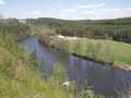
The river sources in Austria on southern slopes of Novohradské Mountains in an altitude of 990 m. To our territory flows before the community of Nová Ves as a small river navigable for sporting boats. From the border up to Tábor, it flows in northern direction, near Tábor it turns with sharp bend to the left in southwestern direction and near Týn nad Vltavou it surges in Vltava from the right side. The total length of navigable parts makes 146 kms.
Lužnice is a plain river, its slope is quite moderate, only in a section Tábor-Bechyně, the valley becomes nearer and in a stony river-basin are easy navigable rapids, the slope exceeds 1‰. The river flows with its moderate, proportionally spring, through plain, meadow countryside of South Bohemia. Its water is stopped with many weirs and is supplying the system of ponds. Lužnice river flows through biggset Bohemian pond, Rožmberk, its piers are protected from rush of flooding with artificial flow, Nová řeka (New river) which takes water-excess to Nežárka river. Lužnice is very popular river for navigations during holidays.
Accommodation:
Attention,. in a locality around Rožmberk pond the camping is not allowed!
Food supply:
It is available in Suchdol nad Lužnicí, Veselí na Lužnicí, Sezimovo Ústí, Tábor and Bechyně.
First aid:
It is available in health centres in Suchdol nad Lužnicí, Veselí nad Lužnicí, Sezimovo Ústí, Tábor and Bechyně.
Places of interest
Suchdol nad Lužnicí: Gothic church of 18th century.
Soběslav: rest of Gothic castle, two Gothic churches.
Tábor: two Gothic churches.
Bechyně: three churches


