
River Elbe - Czech republic
The river sources on Labska meadow in Giant Mountains, it mouths in North Sea in Germany.
1154 km
| Basic information about river river sections Kilometrage Localites | Services Article Fotogallery Videogallery | Discussion Water stages |
Localites
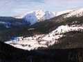
Horní Mísečky - Medvědín Ski Area
Ski centre
Region of Hradec Králové, Trutnov district
This ski area is placed not far from the town of Špindlerův Mlýn, Region of Hradec Králové, Giant Mountains, in an altitude of 710-1235 metres above sea level.
Ski Area Medvědín offers in winter the followng services:
- nine ski slopes and nine ski lifts. Stage of difficulty: blue-black
- evening skiing
- ski running routes, total length makes 37,5 kms
- tandem paragliding
- excursions on sledges
- snowpark
- ski learning schools
- ski and snowboard rent
- skibus
- refreshment
- accommodation: in hotels and lodging houses on spot
- parking
During summer season, Horní Mísečky is very popular resort, suitable for wandering excursions and cycling. The treansfer by means of seat lift Špindlerův Mlýn-Medvědín is possible. Route length makes 1912 metres.
Ski lifts:
|
Name |
Lenght in meters |
|
Špindlerův Mlýn - Medvědín |
1912 |
|
Labská |
1319 |
|
Davidovy boudy |
1179 |
|
Horní Mísečky - Medvědín |
937 |
|
Medvědín |
935 |
|
Horní Mísečky - parking |
409 |
|
Hormony |
250 |
|
Horní Mísečky - meadow |
227 |
|
Horní Mísečky - Hořec (Gentian) |
225 |
Ski slopes:
|
Name |
Lenght in meters |
Exceeding in meters |
|
Medvědín - red |
2300 |
490 |
|
Horní Mísečky-Vodovodní cesta - blue |
2100 |
510 |
|
Labská - red |
1770 |
310 |
|
Davidovky - red |
1500 |
200 |
|
Horní Mísečky-Turistická (tourist) - blue |
1300 |
240 |
|
Medvědín-Tréninková (training) - red |
1100 |
200 |
|
Medvědín - black |
1000 |
280 |
|
Harmony - blue |
300 |
50 |
|
Cvičná louka (training meadow) - blue |
300 |
40 |
Running routes
|
Name |
Lenght in kilometers |
|
Four Men Crossroads - Vrbata Cottage - Horní Mísečky - Medvědín Low Seat Station |
13 |
|
Horní Mísečky - přes Třídomí - Benecko |
10,5 |
|
Horní Mísečky - přes Janovu Horu - Benecko |
10,5 |
|
Racing circuit route VI |
10 |
|
Racing circuit route V |
7,5 |
|
Racing circuit route IV |
5 |
|
Racing circuit route III |
3 |
|
Leading route towards Labský důl |
2,5 |
|
Leading route towards shooting area |
2 |
|
Racing circuit route II |
2 |
|
Racing circuit route I |
1,5 |

GPS: 50°43'16.02"N, 15°36'47.252"E
Text: Tereza Flašková
Photo: Google.com


