
River Robečský potok (Robečský brook) - Czech republic
This brook sources in an area of Ralsko, near to Bílý Kámen (White Stone) in an altitude of 277 m of sea level.
25 km
| Basic information about river river sections Kilometrage Localites | Services Article Fotogallery Videogallery | Discussion Water stages |
River description:
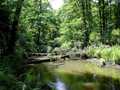
This brook is navigable within moderatly higher water level in an area. Anyway, the navigability can be estimated near to Zahrádky Bridge according to common rule: if the river is navigable under the bridge, so the whole flow is navigable. The brook sources in an area of Ralsko, near to Bílý Kámen (White Stone) in an altitude of 277 m. It turns to northwest, succesively flows through Břehyňský pond, Mácha Lake and Novozámecký Lake and mouths to Ploučnice river from the left side. Its river-basin makes 287 km². The brook flows-in its navigable section-through Peklo (Hell) valley between sandstone rocks, afterthat turns round through a plain via overgrown and set down river-bed. The width does not exceed 5-6 m. Except of boats carrying over, the brook does not have the difficult places.
Accommodation:
A suitable camping place is available in Robeč, many other you find in an area of Mácha Lake.
Food supply:
It is available in Zahrádky and Česká Lípa.
First aid:
It is available in health centre in Česká Lípa.
Places of interest:
Novozámecký rybník (Pond): a pond of 14th century, mostly overgrown with reeds – National Protected Reservation.
Zahrádky: Renaissance castle of 16th century, people´s houses.


