
River Rotava - Czech republic
spring (source):
The river sources in Ore Mountains near community of Přebuz in an altitude of 890 m of sea level.
The river sources in Ore Mountains near community of Přebuz in an altitude of 890 m of sea level.
flow length:
5 km
5 km
| Basic information about river river sections Kilometrage Localites | Services Article Fotogallery Videogallery | Discussion Water stages |
River description:
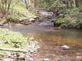
Rotava river is navigable during snow thaw in spring or after heavy rains. The navigability is to be estimated according to upper flow of Svatava river, bur Rotava river needs more water.
The navigation requires more experience in quick flowing streams in unclear river-bed.
The river sources in Ore Mountains near community of Přebuz in an altitude of 890 m.
It flows to southwest and mouths into Svatava river near Rotava. Its river – basin makes
74 km². This small river is of character of torrent, flowing throughout afforested valley with narrow stony river-bed, very often unclear. We recommend you to check the weirs before navigation.
Accommodation:
It is available in camping places along the river.
Food supply:
It is available in Rotava and Kraslice.
First aid:
It is available in health centres in Rotava and Kraslice.
Places of interest:
The centre of the area are Rotava and Kraslice.


