
River Smutná - Czech republic
spring (source):
This river sources in Vlašim Highlands in southern direction of Prčice in an altitude of 640 m of sea level.
This river sources in Vlašim Highlands in southern direction of Prčice in an altitude of 640 m of sea level.
flow length:
47 km
47 km
| Basic information about river river sections Kilometrage Localites | Services Article Fotogallery Videogallery | Discussion Water stages |
River description:
Smutná river is navigable at moderate higher water level, this occurs after heavy rains or after leading out of ponds. However, the navigation is slow, owing to often carrying over of boats for many trees laying in river-bed.
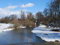
Smutná river springs in Vlašim Highlands in southern direction of town of Prčice in an altitude of 640 m. Its flow directs mostly to the south up to its mouth to Lužnice river in Bechyně. Its river basin makes 247 km². Smutná river flows first through ponds in the outskirts of Jistebnice, and from sepekov flows through not deep deserted valley with many turnings, partially afforested. The river-bed is only 4-6 wide, overgrown or barricaded with laying trees. Anyway, there are not many weirs on the flow.
Accommodation:
You can find it in Bechyně and environs. As to camping places, we find it along Lužnice-river only.
Food supply:
It is available in Sepekov, Opařany, Srlín and Bechyně.
First aid:
It is available in health centres in Sepekov, Opařany and Bechyně.
Places of interest:
Sepekov: shrine church of 18th century, great pilgrimages.
Rataje: people´s architecture.
Bechyně: see Lužnice.


