
River Spůlka - Czech republic
spring (source):
This river sources in Bohemia Forest, in northern direction of Přilba Hill, in an altitude of 1099 m of sea level.
This river sources in Bohemia Forest, in northern direction of Přilba Hill, in an altitude of 1099 m of sea level.
flow length:
13 km
13 km
| Basic information about river river sections Kilometrage Localites | Services Article Fotogallery Videogallery | Discussion Water stages |
River description:
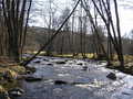
River Spůlka sources in Bohemia Forest, north of Přilba Hill in an alzitude of 1099 m. It flows to the east and mouths near to Bohumilice from left part to Volyňka river. The river basin makes 104 km². This small river flown through partially afforested dense populated valley, its river bed is narrow, attention, low foot-bridge or laying trees in river bed can surprise you suddenly!
Spůlka river is navigable at higher water level after snow thaw or after heavy rains. The water register would show 75 cm at least, or further water register in Čábuzy would show 55 cm at least. The navigation follows quite quickly, a stop could be caused only by laying trees in river-bed.
Accommodation:
Ther are no camping places along the river but accommodation could be secured in communities of Stachy, Čkyně or Volyně.
Food supply:
It is available in Stachy, Zdíkovec, Čábuze and Čkyně.
First aid:
It is available in health centres in Stachy and Čkyně.
Places of interest:
Stachy: carpentered houses, holiday resort of Bohemian Forest.
Zdíkovec: originally Romanesque church, arranged in Neo-Gothic style.
Čábuze: people´s architecture.


