
River Vltava - Czech republic
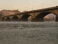
Vltava river is created by confluence of Teplá (Warm) and Studená (Cold) Vltava in a natural preserve Mrtvý luh near to the community of Nová Pec in Bohemian Forest.
430 km
| Basic information about river river sections Kilometrage Localites | Services Article Fotogallery Videogallery | Discussion Water stages |
Localites
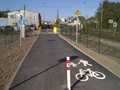
Prague - Braník - Komořany
In-line Locality
Braník, Komořany
It is a coast path between railway line and a river. However, from railway crossing of „U Soutoku“ street (parking, GPS: 50 degree of norhern width exactly!) is very narrow (2 m only) along the stream, round old railway building and sugar-beet factory. Further, to Modřany-Sluice, it becomes wider. From subway, at sluice, it is old road, surface 3, at railway-line level (Modřany-stop) – Povodňová street, following chocolate factory surface 2, up to golf playground (V Náklích street) where you continue straight to skatepark (U Kempinku street, parking place, surface 2-3, car traffic), but it is better to turn to the left among playgrounds up to Vltava-river (surface 1), continue along the stream through alleys under railway-bridge up to ice-cellars, where with short and rough section connects the terrain „Braník-Ice-cellars“.
Access: via Modřanská and Komořanská streets: all subways under tramway-line and railway-line (U Kempinku, V Náklích, K Jezu, Povodňová, U Kina, U Soutoku). Northern direction at Braník Brewery. Southern direction: between Modřany and Komořany in a bend (sign SOLARA).


