
River Vydra - Czech republic
The river is created by confluence of Modravský and Roklanský potok (brook) in an altitude of 978 m of sea level.
12 km
| Basic information about river river sections Kilometrage Localites | Services Article Fotogallery Videogallery | Discussion Water stages |
River description:
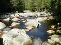
This river is created by confluence of Modravský and Roklanský potok (brook). Vydra flows to the north up to the confluence with Křemelná near to Čeňkova pila. The river of Otava startes by confluence of Vydra and Křemelná. The river basin of Vydra makes 146 km2. The whole river flows in Šumava (Bohemian Forest National Park). The river flows from its confluence through bouldary bed in nice romantic valley of central Šumava, where the big slope is moderated in short sections only. After King´s homestead Antygl the river cuts into deep afforested valley, where the water falls with big slope accorss huge boulders towards Čeňkova pila. This section belongs to the most difficult in our rivers.
As to tributaries: Roklanský potok (brook) as well as Modravský potok (brook) are passable.
River of Vydra is navigable during snow-thaw or after heavy rains only. The flood several years ago changed the bed and damaged the way from Antygl to Čeňkova pila. The passage could be checked on water index at confluence of both brooks, minimum sign is 65 cm, better is 75 cm. Provided the water index signs 100 cm, the river is very difficult for passage as the stream has a great power. However, it is not allowed to drive along the flow, owing to the protection of nature. The upper section can be driven within an hour. The lower section is an expedition case with proper protection, moreover, the optimal water-level is a must. The river is dangerous at high water-level, when there is a lack of water, it is not passable. We recommend you therefore to study first the conditions and situation.
Accommodation, Food-supply, First aid, Places of interest:
The centre of all services is situated in Modrava.


