
River Ipel' - Slovakia
The river sources in Slovak Ore Mountains below Vepor Hill.
163 km
| Basic information about river river sections Kilometrage Localites | Services Article Fotogallery Videogallery | Discussion Water stages |
River description:
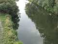
This river sources in Slovak Ore Mountains below Vepor Hill. At first, it flows towards south, later towards west. After Krupinice-river mouth, it turns, in great circle, to the south, up to its mouth into Danube-river, where it flows from left part, and in a place, where Danube leaves territory of Slovakia. However, this river was shortened in big measure by regulation, especially in frontier area.
Upper flow of Ipel river passes through mountain valley, with violent stream and many rapids. Passing community of Holiška, it flows into Lučenska basin, and quicky diminuishes its slope and starts the meandering of its flow. After short section, when it flows through narrow valley, enters into Ipel basin, bordered with headlands of Krupina Highland in the north.
For a section Breznička-Holiška, there is necessary to have high water level for navigation. After the community of Holiška, Ipel-river is navigable at standard water level conditions.
Accommodation:
It is available in Hrkovce.
Food supply:
It is available in Breznička, Bušice, Šahy and Kubáňovo.
First aid:
It is available in Breznička, Bušice, Šahy and Kubáňovo.


