
River Rajčianka - Slovakia
This river sources in Strážov Highlands.
32 km
| Basic information about river river sections Kilometrage Localites | Services Article Fotogallery Videogallery | Discussion Water stages |
River description:
The river sources in Strážov Highlands in southwest direction from the community of Čičmany. At first, it flows in northeast direction, and from Fačkov continues to the north up to its mouth into Váh-river, not far from the town of Žilina. River basin makes 360 km², the length of navigable section is 32,6 kms.
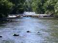
In its upper section, this small river with flat stony river bed and big slope, flows throughout nice countryside in deep valley, which is formed with Malá Fatra Mountains from right and Strážov Highlands from left side. Late, the valley is becoming wider, and when it sinks, the stream is constantly very quick. Anyway, the navigation is difficult, as Rajčianka river-bed is comparatively narrow, and rather unclear in several places. Along whole flow, there are nine weirs, most of them are passable, however, some are damaged. Within descent of these weirs, there is to be recommended to investigate it in advance.
In its lower part, the river is regulated and has several perpendicular stages.
Accommodation:
It is available in the town of Žilina.
Food supply:
It is available in Fačkov, Rajec, Rajecké teplice, Poluvsie, Porubka.
First aid:
It is available in Rajecké Teplice and Žilina.
Places of interest:
- Rajecké Teplice - spa with thermal springs. Medical treatment of moving organism are being made here.
- Lietavská Lúčka - near to this community, there are to be found the ruins of Lietava Gothic castle.


