River Topľá - Slovakia
The river sources in Čergov Highlands.
103 km
| Basic information about river river sections Kilometrage Localites | Services Article Fotogallery Videogallery | Discussion Water stages |
River description:
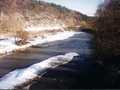
This river sources in Čergov Highlands under Minčol Hill, with two spring flows, connected later below Malcov. It flows in eastern direction, anyway, below the town of Bardejow it turns towards south, and mouths from right side into Ondava river, not far from the community of Sačurov. River basin takes 1595 square kilometres, the length of navigable part makes 103 kms. This river is navigable from Bardejov. At first, it flows violently through wide valley, dividing often into several arms or is changing its river-bed. The navigation is not too difficult, it is possible to do it in open boats (vessels).
Below Marhan, Topla becomes more quiet, its slope is disappearing, and the river cuts into clayed banks. Its stream is quiet, with shelters and pools, and flows liberately up to its mouth.
Accommodation:
It is available in the town of Bardejov.
Food supply:
It is available in Bardejov, Giraltovce, and Vranov nad Toplou.
First aid:
It is available in Bardejov, Giraltovce and Vranov nad Toplou.
Places of interest:
- Bardejov: town´s monument preserved reservation with important fortifications Town hall in Gothic-Renaissance style and Gothic church with wing altars (1448 - National Culture Monument), late Gothic secondary school of 1508, other Gothic church and monastery, Šariš Museum. Not far from here, there is situated spa Bardejovske Kúpele, with skansen of people´s architecture