
River Oravica - Czech republic
The river sources on north slopes of Roháče Mountains.
20 km
| Basic information about river river sections Kilometrage Localites | Services Article Fotogallery Videogallery | Discussion Water stages |
River description:
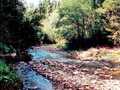
This river sources on north slopes of Roháče Mountains. At first, it flows to the north, at community of Vitanová it turns towards west, and finally, from the town of Trstená up to its mouth in Tvrdošín, flows in southwest direction. Its river basin makes 160 square kilometres, navigable section is 20 kms long.
In its upper section, Oravica has a character of torrent, flowing throughout deep afforested valley. From the community of Vitanová, its slope is getting lower, and the valley is becoming wider. This small river flows through nice open countryside, the banks are partially afforested. So, the navigation could be recommended even less experienced watermen, and in open boats (vessels).
Accommodation:
It is available in the town of Trstená.
Food supply:
It is available in Vitanová, Čimhová, Trestená and Tvrdošín.
First aid:
It is available in Trstená and Tvrdošín.
Places of interest:
- Trstená - Orava Home Museum. Starting point into Skorušina Mountain Range. In the town, you can find originally Gothic church (later rebuilt), Baroque church and monastery, potter owen of 19th century.


