
CZ– An Afternoon Trip on Mountain Bike from Radotín to Karlštejn
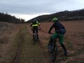
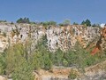
We get off at the Praha-Radotín station and drive along Prvomajová Street to the main road, after which we immediately connect to the A11 cycle path, which first passes through Hadravská Street. Follow the A11 for about 1.5 km and then turn left into V Sudech Street. We drive under the tracks and the Kosoř - Černá rokle nature trail begins right behind them. We set off along it along the Šachetský brook and the Klapice hill. After 2 kilometers, we turn left onto a forest road. It leads around a small gorge, which will be appreciated especially by cyclists with a desire for adrenaline.


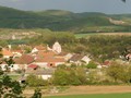
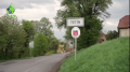
The path soon closes us again to the Šachetský stream and in front of the Old Cemetery in Na Pískách we turn left and join the red E10 St. Jacob's Way. At 2.3 km we pass the Sulava signpost and we still stick to Svatojakubská, even though after another 300 meters we pass another signpost called Kulivá hora. After another less than 2 kilometers we arrive in the center of the village Solopisky and head along the main road Karlštejnská (for bicycles marked as 8100) downhill and then turn right on the blue marked forest road.

Follow the blue trail uphill for almost 1.8 km to the U Památného dubu signpost. From here we start to descend again and after about a kilometer we reach the Pod Vrškem signpost in the village of Vonoklasy. We disconnect from the blue and cross the streets Na Parcelích and K Bulovce again to the red route E10 Svatojakubská cesta.

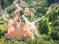
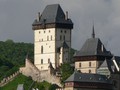
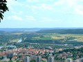
After less than a kilometer, we pass the Na Kunšov signpost and keep to the red light and drive along the Bukovka hill, passing through the Karlický valley, the village of Mořinka and along another Haknová hill. After less than nine kilometers, we leave directly under the castle in the village of Karlštejn and disconnect from the red light.

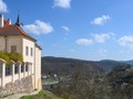
Following the Karlštějn nature trail, we continue to the post office, where we connect to the 8219 cycle path and after 1.5 km we arrive at the Karlštejn train station. We have over 20 kilometers in our feet, mostly through forest terrain. The path is ideal for bikers, it can be managed by owners of more ordinary mountain bikes or hikers. Not suitable for road bikes.

GPS: Karlštejn 49°56'04.4"N 14°11'05.7"E
Text and photos: Veronika Schubertová
| Discussion at the article (0) |
Related Articles
CZ, A Trip to Quarries near Beroun
CZ, Svatý Jan pod Skalou – A Trip to the Heart of the Bohemian Karst – VIDEO
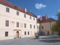
CZ, Nižbor: Baroque Chateau and Glassworks in the Heart of the Forests of the Křivoklát Region – VIDEO
CZ, Koněpruské Caves – The Longest Caves in Bohemia
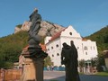
CZ, Karlštejn – The Most Sacred Place of the Kingdom of Bohemia
CZ: Tetin – Place of Pilgrimage and A Stronghold above the Berounka River – VIDEO
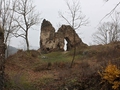
CZ, Skryje: Ruins of Castle Tyrov
CZ, Beroun: Ded Lookout Tower – A Walktrough the Land where Vaclav Talich Drew Inspiration from
Related Videos
CZ, Svatý Jan pod Skalou – A Trip to the Heart of the Bohemian Karst
Nižbor: Baroque Chateaux and Glassworks in the Heart of the Forests of Krivoklat
CZ: Tetin – A Place of Pilgrimage and Stronghold above the Berounka River


Guide:
Important Information:
![]() Information and warnings on travelling abroad is to be found HERE.
Information and warnings on travelling abroad is to be found HERE.
Mobile application:

![]()
![]()


