
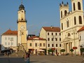
SK, Kremnica – Tourism as It Should Be
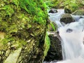
We planned the trip to take us entire day. Upon packing everything we needed we set off following the blue-yellow tourist trail leaving Kremnice downtown and the visitors' center behind. Gradually, we passed the edge of Bujacia Luka nature reserve. It is the place where Heuffel saffron grows. Tourist trails were splitting at a crossroads. We followed the blue trail than and crossed railroad. Mere hour and half later, we crossed Tri Studny and Trojice points and were approaching Hostinec hut, our first stop.

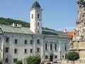
This is the only mountain tourist hut which is a place where you can rest and also eat something in the Kremnicke Hills. Hostinec hut has some long history since it is situated on the former postal route which connected mining towns in the area. As of today, it is administed by the Club of Slovakian Tourists. Once a postmen's inn they transformed it into a touirst cabin. It was rehabilitated in 2005. It is opened to the public. They offer accommodation (you need to book it in advance), drying room, buffe, and pleasant places to spend a while. One such place is situated before the hut. NEarby is also drinking water source - the so called spring of wounded soldier. There is no electricity at hut. Therefore, you can experience how it was before. Interesting is, that every year international cross country skiing championship Bila Stopa takes place there. Be no surprised that the trail is quite frequented in summer and in winter as well. Five tourist trails meet at the hut. You won't get lost.

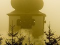
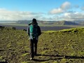
 After a short break we move on to Tri Krize saddle (1180 m). The saddle is situated on the main ridge of the Kremnicke hills making it an important crossroads of tourist trails. Should you try to discover the symbol why the saddle is named Tri Krize (Three Crosses) there is one. It is a triple cross. At the this triple-cross, you can enjoy magnificent vistas over the landscape. We set off further across Velestur and Zlata Studna. We follow the red tourist trail. Walking through forest we climb again, after a section of going downhill. We climb up to Kralicke saddle. m a po výraznějším klesání opět stoupáme, a to ke Králickému sedlu, odkud je jen pár metrů vzdálený Mýtný vrch (1 221 m n. m.) A následně pokračujeme na Bystrické sedlo, kde přecházíme na modře značenou stezku. Zdoláváme posledních pár desítek metrů a dostáváme se na Skalku, sedmý nejvyšší vrch Kremnických vrchů. O geografické správnosti naší polohy nás ujišťuje přítomnost 312 metrů vysokého vysílače Suchá hora, který je druhou nejvyšší stavbou na Slovensku (vyšší je už jen vysílač Dubník – 318 m).


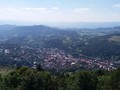
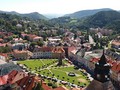
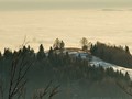
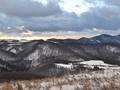
From Skalka, we observe the both sides of the Kremnicke Hills. We see Kraliky village and Banska Bystrica which is further away. We also spotted Skalka resort situated below us. The mountain rescue resides within the resort as well. Interesting fact is that this locality used to be called Slovakian Semmering in the past since there were the all-Hungarian ski races in 1914. Also, the very first Slovakian ski club was founded here. Also, the SNP Heroes Trail goes through here.

Once on Skalka, there are several routes which you can take to get back to Kremnice. The least difficult (of yellow color) goes across Partyzanske valley. Or you can take the red one towards Krahule village. So which one you think we chose? Of course, the one going on the ridge to the mountain village.


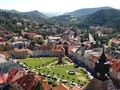
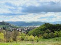
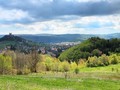
Krahule surprised us – not only we observed significant sports and ski resorts, we also happened to be at the geographic center of Europe. We also visited the recently built wooden observation tower. The observation tower on Krahulsky Hill (959 m) is 13,5 meters high. Up from there, you can see the Kremnice hills, Turcianska basin, Stiavnicke Hills, Vtacik and Ziar as well.

The observation tower was the last stop on our trip. As we were tired after entire day of walking, we went down a forest path to Kremnice. There we went into local restaurant and pondered upon our experiences of the day.
GPS: (Skalka) 48°44'18.9"N 18°59'27.7"E
Text: Oskár Mažgút
Photos: Michaela Kondákorová
| Discussion at the article (0) |
Related Articles
SK, Špania Dolina – Winter Walk in the Area
SK, Marian Columns – Stone Witnesses of Victory over Epidemics III
SK: Marian Columns – Stone Witnesses of Victories over Epidemics IV
SK: Marian Columns – Stone Witnesses of Victories over Epidemics V
SK, Kováčová: An Ideal Place to Rest and for Activities in Nature – VIDEO
Autumn Is Here. Be Sure That You Have The Right Tourist Gear
SK, Region of Banská Bystrica – Significant Mining Region I
SK, Region of Banská Bystrica – Important Mining Region III
SVK: Kremnické Bane - Geographical Center Of Europe
SR, Banska Stiavnica: The Most Impressive Calvary in Central Europe
SK, Banska Bystrica –SNP Memorial
SK, Banská Bystrica – Central Slovakian Gem
SK, Kremnica – City of Humor and Coins
SK, Svätý Anton – Not Just Town for Hunters
SK, Banska Stiavnica: Ancient Beauty Set in Nature – VIDEO
SK, Malachov – A Place Ideal for Tourism II
SR: A Journey From Silver To Jewelry
Related Photogallery
SK, Špania Dolina – Tourism in the Area
SK, Banska Stiavnica – A Town in the Middle of Volcano
SK, Stiavnicke Hills - Winter Tale


Guide:
Important Information:
![]() Information and warnings on travelling abroad is to be found HERE.
Information and warnings on travelling abroad is to be found HERE.
Mobile application:

![]()
![]()


