
Austria, Salzburg Region – Short Trip into the Mountains II
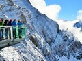
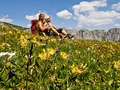
There are observation points. So now we are heading to the first one – Piffkar (1 620 m). This post is intended for children. They learn here about local birds.
platform is at 1850 meters. From there ,you can see Ferleiten valley. Also you can learn more about Rotmoos glacier. We go on to the Alpine Nature Show Museum at 2 300 meters. The museum is focused on Alpine nature, local eco systems, and also local animal species.

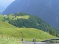
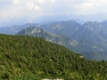
The highest point of the scenic route is Edelweißspitze (2 571 m). You have to turn slightly off the main road. Wonderful panoramas will open you vistas of more than thirty mountains higher than three thousand meters.

Füscher Torl (2 428 m) – there you can observe a memorial designed by Clemens Holzmeister. It is dedicated to the memory of workers who died during construction of this road. And it is here where you have the best view of Grossglockner.
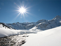
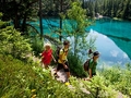
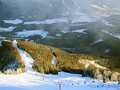
Next we decided to stop at Fuscher Lacke. Near the freeway. We walk around but we re not alone. A herd of cows is our company. After a short break we continue. Only the weather is not the best you can have. It is cloudy and with strong wind. Once we are in the highest point of the trail (Hochtor tunnel at 2 504 m), we think we are in different season. The road is covered with ice and snow. Wonderful.

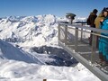
We are getting near the end point of the road – the visitor centerKaiser Franz Josefs Höhe. The altitude is 2 369 m. We are not particularly lucky as for visibility. Dark clouds flow above us. Sometimes sharp flash enlightens the skies. We can see Grossglockner and we can sense there is Pasterze glacier of which we had a few glimpses. I must see this place one more time. How can I miss a vista of the largest glaciers in the Eastern Alps.

The end point of this mountain road has space for 600 cars. Kaiser Franz Josefs Höhe visitor center presents an exhibition on the highest Austrian mountain – Grossglockner. There are many interesting thins on its 1 000 m2 meters. The items are placed across four floors each devoted to different area. You can try to walk through an icy chasm. There you can see the world of ice crystals and fascinating life inside ice caves and learn the history of the trail.
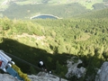
The main attraction is not the exhibition inside the vistor center. The main thing here is the landscape that has fascinating atmosphere. We climb to Franz Josef statue on the hill below us. Unfortunately, everything is hidden in the mist and mountains around are almost frightening.


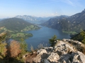
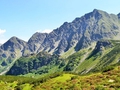
The Hohe Tauern national park (the road belongs to it) is the largest nature reservation in the Alps. It is also regarded as one of the most beautiful in the world.
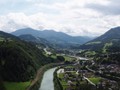
The road back is pretty calm. Even though at some points it is difficult. On the other hand, the road is regularly maintained. The closer we get to the park, the better the weather is. Sun peaks from the skies. The evening is really pleasant eventually.
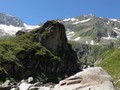
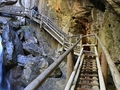
We must count on the road back on our last day. Therefore we go to Lichtensteinklamm gorge. You can see it near Sankt Johann im Pongau, the history of town dating back to the Bronze age. Water erosion created the gorge. The length is almost 4 kilometers. Only small part of it is accessible to the public. However, along it are benches, pavements, bridges and stairs firmly attached to rocks. The gorge is only couple of meters wide but more than 300 meters deep.


You can visit Lichtenstein gorge thanks to enthusiast from the Pongau Alpine club. In the second half of the 19th century, they worked there. Some places would require tunnels except for wooden constructions. Prince Johann II of Lichtenstein gifted money to finish the construction. In his honor, the gorge bears his name.
We saw it early in the morning, supposedly the best and the most suitable time. In the afternoon, light does wonders. I recommend hiking shoes and perhaps a raincoat. Somewhere you can experience cold shower because water sprinkles on pavements. A beautiful waterfall was a pleasant surprise upon 1.5 kilometer hike.


The weather was great. This was really nice conclusion to our accommodation. I believe that soon I will return to the region of Salzburg.
GPS: 47°02'23.5"N 12°50'30.3"E
Text and photo: Magdaléna Radostová
| Discussion at the article (0) |
Related Articles
Austria: Zell am See – A Glacier, Mountains and a Lake
Austria – Mondsee and Zeller See Lakes and Hohenwerfen Castle
Austria – Winter Vacation in the Region of Salzburg
Germany: Ramsau, Berchtesgaden and a Salt Mine
Austria: The Hohe Tauern National Park and the Town of Kaprun

Austria, Dachstein – Rocky Giant
Austria, Drachenwand Ferrate: Fitness, Strenght, Experience
Austria, Bad Ischl – Alpine Panorama from the Top of Katrine Ferrate
Austria: Traunstein – The Guarding Ferrata of the Salt Chamber
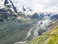
Austria: Pasterze – The Longest Glacier in the Eastern Alps
Austria: Kaprun – Alpine Dams of Wasserfallboden and Mooserboden
Austria, Steiermark – Bärenschützklamm and Hochlantsch Mountain
Austria, Zell am See – Magical Region in Salzburg
Austria, Salzburg Region – Short Mountain Trip I
Austria: Zell am See and Kaprun – Places Where Visitors Feel Great
Austria, Styria – Basilica in Mariazell
Austria: Styria – Too Much Charm for Such a Short Trip
Austria: Styria – Murtal, A Recreation Area
Related Photogallery
Austria: Schneeberg - Two Thousand Meter Mountain
Austria: Paradise for Alpine Hiking Enthusiasts
Austria: Hohe Tauern - Beautiful and Monumental
Austria, Klosterneuburg – Gems in the Town
Ausrtria, Salzburg - Skicircus
Austria, Carinthia – Nassfeld: Great Skiing
Austria, Carinthia – Kötschach-Mauthen Town
Austria: Styria - Walking in Nature III
Austria, Kaprun - Skiing on Kitzsteinhorn Glacier
Austria: Lake Neusiedl
Austria: Styria - Travels in Nature II
Austria: Styria - Travels in Nature I
Austria: the Castle Complex of Schloss Hof
Austria: Erlaufsee And Gemeindealpe - Mitterbach
Austria: Mariazell And Mariazell Burgeralpe
Austria: Vienna - Walk Through City


Guide:
Important Information:
![]() Information and warnings on travelling abroad is to be found HERE.
Information and warnings on travelling abroad is to be found HERE.
Mobile application:

![]()
![]()


