Bolivia – Copacabana and Isla del Sol
Published: 21.7.2023
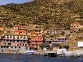
Copacabana is usually the first city in Bolivia a traveller visits when travelling by land from Peru. If not, he should certainly consider the visit. Shall we excuse the city for the mandatory and quite unnecessary fee, Copacabana is a nice and quite place to rest. The vista over Lake Titicaca makes it even better and adds to the atmosphere. The city is small making this resort on the lake a picturesque and magical place. You can easily walk here for how long you want and still enjoy it.
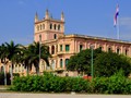
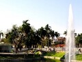
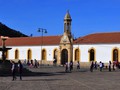
The first place we visited is Plaza 2 de Feberero. There is an amazing white cathedral crowned with the Moor-style domes. It resembles rather a chateau. The interior is impressive as well. Perhaps bit too over-decorated.
")
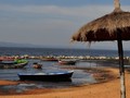
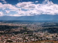
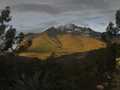
A while before the evening we set off for Cerro Calvario, a hill nearby popular among locals and tourists. The way of the cross crosses it. You can spend a while enjoying the view from over 160 meters above the largest mountain lake (8 400 km2) at 3808 meters above sea level. Omnipresent trash, however, spoiled the experience a bit. It seems it is the working of the locals. However, Santa Barbara, the neighboring hill, provides another splendid vista and there is less trash. Moreover, we were alone there. We finished the day by a walk along the promenade at the lake. Paddle boats had been already parked there. We bought a ship ticket instead for we had intended to visit the island on the following day.


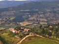
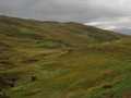
It is early in the morning and we are heading to the wharf and from there to Isla del Sol. It is quite cold. We sit in the cabin rather. The two-hour ride to Challapampa passes quickly as we are observing the environment. Were we up on the upper dack, we would probably get frozen there. We are planning to cross the island from the north to the southern port. There we would sleep over at the hotel. There are several Inca landmarks on the 70 km2 (the Chincana ruins are among the most prominent. However, we had enough of Inca culture in Peru and don't wish to see any more of it for now. Therefore, we pass by a checkpoint situated behind a quiet bay. We say that we want to walk around the entire island. We pass the northern projection of the island up on the ridge. Then we walk on wavy landscape at 4000 meters to the central part of the island.

We enjoy the vistas of large amount of dark blue bays, meandering land, and small islands scattered across the lake. Sometimes it is just a leaned flat rock – such as Isla Jochiuata – rising above the water surface and creating fantastic scenery of Lake Titicaca. There is another checkpoint in the middle of the dust road. They say to us that we have to pay 15 BOBs for walking down the road. Well, I have never payed for using a road, well sidewalk actually, therefore I am enjoying handing over the bills to the man. There is another man trying to get some money out of us four kilometers further in Yumani village which is above the southern port. This is how locals make some extra money here. And I look like a Santa Claus throwing money all around.

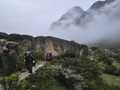
The across-the-island trek is about 12 kilometers long and took us about 4 hours. However, the island is situated at 4000 meters above sea level. Therefore, one can easily wear one out. We went down the Inca stairway (Escalera del Inca) on our way to the village. The stairway goes down to the port. Fuente del Inca was a garden we passed. Our intention to stay over night on the island changed once we found out the cost. We rather returned to Copacabana. It costs 20 BOBs to get from Copacabana to island's southern end. However, the return ticket's costs jumps to 25 BOBs. Local ticket vendors laughed at us. You can read in their eyes: "WELL, DON'T PAY. I WOULD LIKE TO SEE HOW YOU CAN GET OUT OF HERE." The way out of the island is even faster. Aboard the ship, people were tired and so were we. The island is without trees. We walk entire day with sun above our heads. The high altitude makes sun shine even harsher on skin.


Apart from constant fees and burned ear skin Isla del Sol was a great experience. A stay in Copacabana was nice as well. It brings the apropriate atmosphere before your visit to the Island of Sun (Isla del Sol). On our way to La Paz, we enjoyed the last vista over the lake. The main road to the city goes along the lake. You even need to corss it by ferry at one place.
GPS: 16°10'05.9"S 69°05'18.0"W (Copacabana)
Text and photos: Tomáš Novák

Related Articles
Published: 29.9.2023
Paraguay is rather a small Southern American country. Still, its area of 406 750 sq kilometers means it is 5x larger than the Czech Republic. Therefore, tourists are motivated to move slowly and to visit small and quieter towns. We hitchhiked one man who told us that only Asunción, Encarnación and Ciudad del Este are considered cities in Paraguay. The rest are villages. And we would soon find it out by ourselves.
Published: 22.9.2023
Before we get to Asuncion we need to ride through Gran Chaco which spans across Argentina, Bolivia and Paraguay. It covers most part of Paraguayan north where most of the war with Bolivia took place in the 1930s. Paraguay won it. The reason for the wall was that both parties mistakenly believed to hold oil resources. Today it is just empy wasteland covered of grass and trees.
Published: 15.9.2023
Santa Cruz de la Sierra is the largest city in Bolivia. It is situated in the central-eastern part of the country far from the Ands. It stretches on flat land. It is remarkable to view the city from bird’s eye perspective. It is of eliptical shape consisting of three bypass circuits (anillos). These are interconnected by radiales – main roads to which are given numbers clockwise. There are 27 of them.
Published: 8.9.2023
It is an amaizng experience to buy tickets in Bolivia. It also tries nerves of you and the person who tries to sell you them. We buy tickets to Samaipata village in Sucre. Samaipata is on the way to Santa Cruz de la Sierra, supposedly the last city in Bolivia we would visit. Our intention is to rest for a while in Samaipata for we have been in large crowds for the last couple of days.
Published: 1.9.2023
Sucre is the most beautiful city in Bolivia with the best well-preserved colonial architecture we have seen so far. It is also the cleanest and most well-maintained city in the country. Somehow you can feel the order and will of the people to keep the city nice. I tis elegant, simple by colors, and locals are proud to walk around it. It is more or less of the size of Potosi. Around quarter million people live there. Sucre was added to UNESCO World Heritage Sites list in 1991.
Published: 25.8.2023
The road from Uyuni to Potosí takes mere three hours. It would be nothing less but a sin not looking from the window. The road goes up hill when leaving flat desert region. It crosses low yet beautiful Rainbow Mountains. The land has still features of desert. It is quite dry and without large vegetation Lamas and nandas could be spotted along the road.
Published: 18.8.2023
Our plans receive significant blow once we found out at the terminus in Cochabamba that bus driving companies are on strike. This is nothing unusual in Bolivia. We spending there our second week and we happen to see second one. However, inhabitants and employees have good attitude towards it and they are hardly annoyed. We have ben told several times that such a strike lasts about three days at least.
Published: 11.8.2023
The fastest and easiest way to get to Torotoro village from La Paz is by night bus from Cochabamba. There you transfer to colectivo (local form of public transportation. We wonder through the terminus in Cochabamba at 5:45. A lady at the information stall is even more sleepy than we are. Yawning she told us that we have to go to another terminus.
Published: 4.8.2023
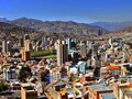
La Paz interested me the most of all places in Bolivia. I have always considered its unusual altitude interesting. I have always thought about how people live at 3600 meters of altitude. After I have spent some time at these altitudes in Ecuador or Peru, I have found out it is not hard at all. One gets simply used to it. Still, La Paz is quite a phenomena among large world cities for how high it is located.
Published: 28.7.2023
We leave sunny Copacabana and travel through La Paz to Coroico, a small village we deliberately chose to spend several days in nature. There goes direct line of public transportation (collective) from La Paz. It takes about three hours. We need to go from the altitude of 3600 meters (La Paz) even one kilometer higher. Then we would go donw serpentines to Yungas region (a region between the Andes and lowland forests). In this region there is the “death road”, a Bolivian attraction. Since 2006, there has been opened an asphalt road. Therefore the muddy road which used to be “world’s most dangerous road”. Every year allegedly 300 people died there. Today, only bikers use it.
Published: 2.8.2013
Cochabamba is the capital of the Cochabamba Department that cover the area approximately of Slovakia. This department is well-known in the country for its fertile soil thus its nickname is “granary of Bolivia”. Among agriculture products cultivated there are grains, tobacco, sugar cane, potatoes or cocoa beans.
Published: 17.11.2010
After arrival to Peru, we transferred from Lima to the moumtains. At seven o´clock in the morning, we came to the locality of Huaraz, situated in an altitude of 3091 metres above sea level.
Published: 10.11.2010
South America was always for me a great attraction, a magnet. Me, as a girl-undergraduate, who does not have big incomes, it seemed to be something as an inaccessible dream for the time being. Nevertheless, my college Vojta, said to me recently: "Would you like to visit South America, Peru, Chile or some other country?" and this offer let an idea in my head.
Published: 24.11.2010
In the morning, I went to bus station to take my rucksack, as my luggage did not arrived to Lima in time. After several call phones, we settled with KLM airflight company, that the luggage will be brought there in the bus.
Published: 1.12.2010
As our first trek in Peru, we have chosen well-known and often visited route through Santa Cruz Valley-river. Guide information says that optimal march time period is stipulated for four days, and the distance from starting point up to final one makes 50 kms. Anyway, we planned that our trip would be one day longer, including climbing into base camp of Alpamayo Mountain.
Related Photogallery
Bolivia is usually not the main goal for tourists coming to South America. Fortunately, our corre...

")