
Across Mountain Range Of Bohemian Forest - Czech republic

Cycling of curve
Across Mountain Range Of Bohemian Forest
Your excursion could be started from parking place, following blue marked tourist trail, and later along marked cycling route No.2100 towards the community of Hojsova Stráž. Further, you continue your drive, mostly descending above Zelensky brook Valley, joining railway line, crossed at Zelená Lhota railway stop. Here, you turn aside to the left, following marked cycling route No. 2053. On your left part, you see Nýrsko water reservoir.
In Hamerský Dvůr, you join marked cycling route No. 33. You can eventually have a look on this dam, including its pier and divertion to the town of Nýrsko. Anyway, you continue to Hamry and turn aside to the right towards cycling route No. 2102, passing Bílý potok. Now, decent effort is expecting you, up to crossroad known as „Stateček“ could drive upstairs active sportsmen only. Further, you cross Bílý potok in a place, where Bílá strž (White Gap) reservation is situated. You can have a look a waterfall from diversion of red marked road, known as „Horizontala“. You drive upstairs, after 2 kms distance, you reach the crossroads, and from here, you can walk on foot towards 250 m distant waterfall.
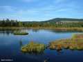
Finally, last mounting ahead, and you are nearly at the end of your tour. Some nice views, and you are just in front of Jezerní stěna (Lake Wall), and you descend down to banks of Black Lake.
Your return drive via Opičák Col, is short and comfortable.
Route length: 34 kms
Character: this route is of middle stage difficulty


Localities:

Important Information:
![]() Information and warnings on travelling abroad is to be found HERE.
Information and warnings on travelling abroad is to be found HERE.
Mobile application:

![]()
![]()


