
Beskydy - Czech republic
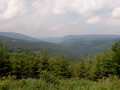
Beskydy Mountains are situated in the eastern part of Czech Republic near to the border with Poland and Slovakia . They are formed by Moravian and Silesian Beskydy and its environs, Štramberk Highlands and the northern part of Vsetín Hills. The highest point of Beskydy is Lysá hora (1323 m), on the frontier of Poland and Slovakia , in an area of Oravské and Zywiecké Beskydy there is Babia hora (1725 m). On the territory of Beskydy there is extending Protected Natural Area Beskydy.
| Lokalities Subjects | Articles Photogalery | Videogallery Discussion |
Lokalities

Čertův Mlýn (Devil's Mill) Educational path
Educational path
Nový Jičín district
This is newly reconstructed educational path, open for public since 1st August 2008. Its name is derived from Čertův mlýn (Devil´s Mill), one of tops of Moravian-Silesian Beskydy Mountains. The route leads from Pustevny, along steep of Devil´s Mill. You find new information tables here, giving detailed information about places of interest, situated in Kněhyně-Čertův mlýn National Nature Reservation. The path follows red marked tourist trail and marked cycling route. This route is also suitable for cyclists, but these could be more considerable to foot-passengers. Moreover, ski-runners can use this path in winter.
The way leads around Mořské oko (Sea Eye) small lake up to Pustevny place. Along the route, there are to be found nine stops, informing you how local countryside changed, which sorts of plants could be seen here and which kind of animals are moving and living in the area.
Route length: 8 kms


Mountains / Europe / Czech republic

Important Information:
![]() Information and warnings on travelling abroad is to be found HERE.
Information and warnings on travelling abroad is to be found HERE.
Mobile application:

![]()
![]()


