
Beskydy - Czech republic
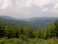
Beskydy Mountains are situated in the eastern part of Czech Republic near to the border with Poland and Slovakia . They are formed by Moravian and Silesian Beskydy and its environs, Štramberk Highlands and the northern part of Vsetín Hills. The highest point of Beskydy is Lysá hora (1323 m), on the frontier of Poland and Slovakia , in an area of Oravské and Zywiecké Beskydy there is Babia hora (1725 m). On the territory of Beskydy there is extending Protected Natural Area Beskydy.
| Lokalities Subjects | Articles Photogalery | Videogallery Discussion |
Lokalities

Jablunkov valley route
Cycling of curve
Frýdek - Místek district
This route belongs to easy, but long routes. We start our excursion from Třinec along marked cycloroute No. 6085 across community of Vendryně, in Bystřice we turn to the left along marked cycloroute No. 6086. On right side, there is place nature monument called Filipka, we pass Krkavice Hill and, on left side we pass nature reservation called Pleninsko. We arrive to the community of Písek, turn to the left on cycloroute No. 56, and in community of Bukovec to reach marked route No. 561 to Hrčava. We continue the same route, on left side we can see preserved nature reservation of Vřesová stráň (Heath Slope). We turn to the left to cycloroute No. 6081, on left part we continue up to the community of Rovné. Afterthat, we turn to the right on a road, leading via Záhoří, and shortly we arrive back to Třinec.
Route length: 87 kms
Character: easy, but long route
Photo: Wikipedia.com


Mountains / Europe / Czech republic

Important Information:
![]() Information and warnings on travelling abroad is to be found HERE.
Information and warnings on travelling abroad is to be found HERE.
Mobile application:

![]()
![]()


