
Beskydy - Czech republic
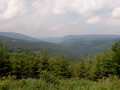
Beskydy Mountains are situated in the eastern part of Czech Republic near to the border with Poland and Slovakia . They are formed by Moravian and Silesian Beskydy and its environs, Štramberk Highlands and the northern part of Vsetín Hills. The highest point of Beskydy is Lysá hora (1323 m), on the frontier of Poland and Slovakia , in an area of Oravské and Zywiecké Beskydy there is Babia hora (1725 m). On the territory of Beskydy there is extending Protected Natural Area Beskydy.
| Lokalities Subjects | Articles Photogalery | Videogallery Discussion |
Lokalities
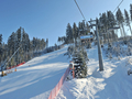
Ski Area Vítkovice Bílá
Ski centre
Region of Moravia - Silesia, Frýdek Místek ditrict
Ski-centre Vítkovice-Bílá is situated near to the Slovak border, in south-east direction from the town of Frýdek-Místek, at foot of Beskydy Mountains, Moravia-Silesia Region, in an altitude of 700 metres above sea level. Bílá Ostravice-river flows through the community of Bílá.
This winter sport centre offers the following services:
- descent routes, total length 4,6 kms, are destined for beginners as well as for children and experienced skiers.
- all ski slopes are covered with artificial snow, some of them are illuminated in night
- evening skiing
- three ski-towages and rope-railway
- ski-run circuits, 20 kms and 33 kms long
- snowpark
- ski-schools for beginners and for children
- ski service.
- ski-equipments rent
- refreshment and accommodation services inside ski centre
- parking place with capacity of 450 vehicles
During summer saison, the centre serves for relax and sporting activities
Ski - lifts
|
Name |
Lenght in meters |
|
Rope railway |
250 |
|
South 2 |
156 |
|
South 1 |
101 |
|
Children slope |
5 |
Ski slopes
|
Name |
Lenght in meters
|
Exceeding in metres |
|
Zbojnická II - red |
1050 |
250 |
|
Zbojnická - blue |
1100 |
250 |
|
Zbojnická I - red |
950 |
250 |
|
Spojnice - blue |
300 |
56 |
|
SKI school - blue |
90 |
5 |
|
Jih I - blue |
400 |
100 |
|
Jih II - blue |
700 |
156 |

GPS: 49°26'31.469"N, 18°27'33"E
Text: Stanislava Waniová
Photo: Google.com


Mountains / Europe / Czech republic

Important Information:
![]() Information and warnings on travelling abroad is to be found HERE.
Information and warnings on travelling abroad is to be found HERE.
Mobile application:

![]()
![]()


