
Žďárské Vrchy (Hills) - Czech republic
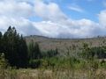
Žďárské Hills form part of Bohemian-Moravian Highlands, situated on border of Bohemia and Moravia. Its highest point is Devět skal (Nine Rocks) of 836 m height. The hills are extended on the territory where were passing many important business trails.
The mining of silver (from 14th up to 18th century) started very important period of this region. As to monuments - most important is those of Church dedicated to St. Johann Nepomuk in Zelená Hora.
In 1970 the hills were declared as Protected Natural Area.
Natural Area of Žďárské Hills was formed on a surface of 715 km2 on 25th May 1970.
One part (465 km2) is situated on the area of Žďár nad Sázavou district and the rest
(250 km2) on the area of Havlíčkův Brod, Chrudim and Svitavy. The boundary of this protected area form appr. four-corner. The highest is Malínská skála (812 m).
| Lokalities Subjects | Articles Photogalery | Videogallery Discussion |
Lokalities

Žďár nad Sázavou - Pilská nádrž (Pilská basin)
In-line Locality
Žďár nad Sázavou, Polička
This in-line route leads along cycloroute No. 5061 around Sázava-river from House of Culture in Žďár nad Sázavou to Pilská Basin. The route is approx. 3 kms long but till the end of 2006 it would be prolonged to the north in about 2 kms more to the community of Polnička.
Access: it is possible in any place on route. Parking places are situated on many points along the route. At starting point – at Culture House in Žďár, in Bezručova street at tennis courts, near to Bránský pond, and near Pilská nádrž (basin) in Tálský Mlýn street.


Mountains / Europe / Czech republic

Important Information:
![]() Information and warnings on travelling abroad is to be found HERE.
Information and warnings on travelling abroad is to be found HERE.
Mobile application:

![]()
![]()


