
SK: High Tatras – To Hladke Klippe Across Koprova Valley
Kôprová dolina – pravá tatranská divočina

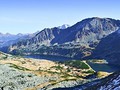
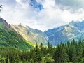
The Koprova valley is 11 km long and spreads on the western edge of the High Tatras. The western part of the valley is bordered by the Liptovske Kopy, which belongs to the Western Tatras as a separate geomorphological subcele. Together with the nearby Tichou Valley, it belongs to a small number of untouched localities in the territory of the Tatra National Park where there is no extraction of calamitous or wood-destroying insects of the affected wood. The regeneration of damaged or destroyed forests remains the exclusive direction of nature. The forests and primaveal forests spread out on this territory live at their own pace without disturbing elements and insensitive human intervention. If we imagine a hike with a crossing over the Závory klippe aiming at the Hladke klippe, we can undoubtedly talk about a beautiful all-day trek, whose trail will lead us into the heart of the true undisturbed Tatra wilderness.
The Route of the Trek

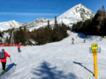
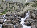
We take a 26 km tour of 1,243 m of elevation. The estimated time to finish the whole trek is 9 hours at least. We start in the parking lot near the "byvala Vazecka chata" signpost. Here we join the red marked tourist trail (aka Tatranian highway), cross the "Tri Studanky" signpost and then head up to the "Nad Bytom" crossroads. Here we continue along the blue marked tourist trail leading through the forest and descend to the Koprova Valley - to the asphalt road where we walk past the signpost "Pod Gruniky". We continue on the road, which is a marked tourist and cycling route. We come to the intersection of "Kmetuv Vodopad", where the cycle path ends and continues only the trail for hikers. We can stop for a moment and turn right to Kmet's Waterfall. After the same trail we will return and with a slight climb we can continue along the blue route to the signpost saying "Hlinská dolina, ústí".
To Zavory Klippe

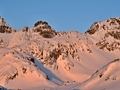
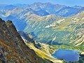
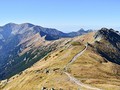
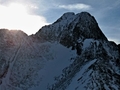
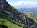
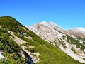
At the crossroads of the hiking trails "Hlinská dolina, usti" we turn left and join the green trail which takes us uphill. We walk through the forest and after a while we pass another important intersection of our tour - the signpost "Pod Temnymi smrcinami." We are experiencing less and less tourists, the trail rises up sharply, gradually leaving the forest and entering the dense vegetation of the tree. With the gradual rise in height, we find ourselves in the open countryside, the scrub is less and it is completely lost. We are located in the Kobyli Valley - the magic and picturesque corner of the Tatra Mountains. There are some fascinating vistas such as of the Temnosmrcinske valley, the Koprovsky pyramidal peak, Mengusovsky pyramidal peak, Cubrin and the massive slope belonging to the main ridge of the High Tatras are fascinating. We constantly ihke uphill until we finally reach the first important destination - the Zavory klippe (1 877 m above sea level). Opposite views of the Ticha Valley and the Liptovske Kopy, the Cervene Hills, the Kobyli valley and the shadow surrounding the Temnosmrecinske valley and Temnosmrecinska lakes.
On High Tatra's Main Ridge

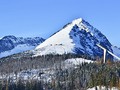
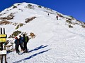
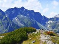
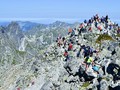
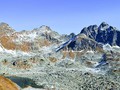
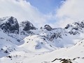
From the Zavory klippe we we follow the red marked tourist trail up to the Hladke klippe. After about 20 minutes of walking we get up to the altitude of 1,993 meters where our destination is. Because of the considerable distance of the Hladke klippe in this section of the Tatras, tourists do not go here that often. There is total tranquility, quietness and comfort. Unobtrusively and without floods, we can enjoy the beauty of the alpine nature of Tatra Mountains. The most spectacular is the view of the Polish part of the High Tatras - the Pieciu Stawow Polskich valley, local lakes and the pyramidal peaks around. We admire the mountains of Svinica (2,301 m above sea level), Kozi Wierch (2,291 m above sea level) and Miedziane (2 233 m above sea level). Far out on the horizon are the distinctive spiky peaks of the Belianske Tatras- Havran and Zdiarska Vidla. The Slovak section of the Tatra Mountains offers a nice view of the westernmost part of the Western Tatras - the mysterious Liptovske Kupy hills which are closed to tourists.


GPS: 49°13'00.1"N 20°02'00.2"E
Text and photos: Radoslav Biskupič
| Discussion at the article (0) |
Related Articles
SK: High Tatras – Winter Hike Up Predni Solisko
SK: Western Tatras – Winter Climb to Placlivy
SK: Downhills on Skialps

SK: High Tatras – Ascend to Krivan
SK, High Tatras: Winter Hikes in Velka Studena Valley
Poland, Zakopane – The Mountains Next Door
SK: Summer with Vistas over the Mountains
SK, High Tatras – Monte Móry Lookout
SK, High Tatras - Climbing up the Furkotsky Shield
SK: High Tatras – Hiking Up Koprovsky Peak
SK: High Tatras – Climbing to Sedlo pod Ostrvou
SK: High Tatras – Hike Up the Popular Peak of Rysy
SK: High Tatras – Climb up to Svinica
High Tatras: Climb on Velka Svistovka
Related Photogallery
SK, High Tatras – Kriváň Gold and Guerilla Fighters
SK: High Tatras – Across Koprova Valley up the Main Ridge of the Tatras
SK: Western Tatras – An Autumn Trip up Baranec Mountain
SK: High Tatras – Up to Rysy
SK: High Tatras – A Trek Up Predni Solisko
SK: High Tatras – Cold Embrace of Velka Studena Valley
SK: High Tatra – In the Winter Realm of Mala Studena Valley
SK: High Tatra Mountains – A Trek Across Mlynicka and Furkotska Valleys

SK: Western Tatras – Climbing Up Ostry Rohac
SK: High Tatras: Winter Impression II
SVK: High Tatra Mountains - From Lake To Lake


Guide:
Important Information:
![]() Information and warnings on travelling abroad is to be found HERE.
Information and warnings on travelling abroad is to be found HERE.
Mobile application:

![]()
![]()


