
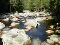
River Vydra - Czech republic
spring (source):
The river is created by confluence of Modravský and Roklanský potok (brook) in an altitude of 978 m of sea level.
The river is created by confluence of Modravský and Roklanský potok (brook) in an altitude of 978 m of sea level.
flow length:
12 km
12 km
| Basic information about river river sections Kilometrage Localites | Services Article Fotogallery Videogallery | Discussion Water stages |
Fotogallery
CZ: Sumava in Autumn I
heading (paragraph): Hills
No. of pictures: 33 pictures
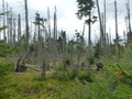
Part of Kvilda is a former settlement of Bucina. Today this town is related to the "Iron Curtain". A border crossing to Germany used to be there. Forests around are located in the 1st zone of the Sumava National Park. In this zone, almost any human activity is forbiden and forests thus suffer under bark beetle. A look at destroeyed plains are rather scenes from some horror movie. Your heart will feel better in Susice by local mechanical Betlehem. Or you will enjoy a view from Klostermann's observation tower. The name to the tower gave well-known writer who used to live in Sumava.
Text and photo: Monika Babická


 |  |  |
 |  |  |


