
River Flájský brook - Czech republic
The river sources in Ore Mountains in peatbogs in northwestern direction of Mikulov at the altitude of 848 m of sea level.
5 km
| Basic information about river river sections Kilometrage Localites | Services Article Fotogallery Videogallery | Discussion Water stages |
River description:
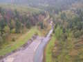
The river sources in Krušné hory (Ore Mountains) in peatbogs in northwestern direction of Mikulov, and in the same direction flows to the state border. Fláje-Dam was built on its flow , under the dam the river is navigable. The river leaves the Bohemian territory near to Český Jiřetín at the altitude of 600 m. The river-basin in Czech Republic makes 68 km2 only.
A short section of the brook has narrow and stony basin with great slope, the trees laying over the basin does not surprise you , the knowledge of landing in strong stream is necessary.
The brook is navigable during letting out of water from the dam, what occurs in spring at presened water-index relating to 60 cm in Český Jiřetín. Attention for a bridge with tubes and sharp roller and low tree-bridges!
Accommodation, First aid, Places of interest:
You find everything in Litvínov.


