
River Blšanka - Czech republic
The springs of Blšanka are to be found on slopes of Doupov Mountains unde Prokopy Hill in an altitude of 675 m above sea level.
28 km
| Basic information about river river sections Kilometrage Localites | Services Article Fotogallery Videogallery | Discussion Water stages |
River description:
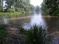
Blšanka river flows to the west in direction of Lubenec, turning to north-east , this direction is held up to its mouth into Ohře river. The river-basin makes 483 km2. The river flows throughout flat valley between meadows and hop-fields. The river-bed is many times surrounded with willow-trees along banks. The river-bed is 4 m narrow, before the mouth it becomes wider up to 8-10 m. However, most of weirs on flow are not passable. The stream is calm without rapids, the only obstacle is new wood along banks.
Blšanka river is possible to be descended after thaw in spring or after strong rains. For the upper section it is a position in Holedeč 90, for lower flow 70 cm on the same index.
The navigation is slow, owing to the fact that the boats are to be carried over the weirs and the obstacles in the river, as there are many trees, for example. You have to calculate with a speed of 3-4 kms per hour. The passage can be run in open canoe, too.
Accommodation:
We do not use camping places along the river.
Food-supply:
Available in the places: Kryry, Očichov, Blšany, Linošovice, Libořice, Železná, Měcholupy, Holedeč, Dobříčany, Žatec
First aid:
Available in health centres in: Kryry, Blšany, Žatec
Places of interest:
- Kryry: look-out-tower on place of former Gothic castle, Gothic church of 15th century
- Měcholupy: Baroque castle of 17th century
- Dobříčany: deserted castle of 17th century, Gothic church, small spa


