
River Doubrava - Czech republic
The river springs in Žďárské vrchy in the south of community of Radostín in an altitude of 626m of sea level.
90 km
| Basic information about river river sections Kilometrage Localites | Services Article Fotogallery Videogallery | Discussion Water stages |
River description:
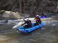
Doubrava river springs in Žďárské vrchy (Žďár Hills) in the south of community of Radostín. The northeastern direction is kept up to its mouth into Elbe at the altitude of 198 m. The river-basin makes 600 km2. The river squeezes Železné hory from table-land of Žďárské vrchy, where forms several exposed places, and mouths - near to the town of Žleby - to Polabská plain. On its upper flow runs between meadows, but near to the community of Bílek cuts into granite basis and in the middle of forests creates marvellous canyon in Valley of Doubrava, where raids the narrow pass - accros big boulders through several waterfalls.
The river bends under the canon, and the slope is increasing from Ostružno up to Pařížov-Dam. The river-bed is wider and more clear, if still stony. The further interesting section is from the dam to Ronov. The rapids under Mladotice are more difficult and romantic. Some watermen races, slalom races and events we taken place here in the past. Near to Ronov the river has a plain character and flows with moderate spring between meadows.
The weirs on the upper flow are damaged, nevertheless, after an investigation are mostly navigable. On the contrary, the river is not navigable on its lower section, and the mill-races take away the water of the riverbed. Doubrava has several exceptionally navigable tributaries - such as Hostačovka and Zlatý potok.
The other rules are valid for various sections, from the water-level point of view. The upper flow, from Sobíňov, is not used, everything starts from Bílek. You can start here, provided the big lagoon under the road-bridge of really full of water. The further rule can be - the absolute non-navigability of metal foot-bridge approx. 200 m distant of this place.
If the river is good navigable under the road-bridge in Libice nad Doubravou, the descend up to Spačice is possible. To this fact corresponds water-level index 90 cm (at bridge in Spačice). The navigability under the pier depends on passage from the dam. The minimum is 7, better is 10m3/sec. The moderate guidance ccould be the water-index in Žleby, with minimum 80 cm. Under Žleby is the river navigable for open boats, also at slightly increased water stand. The descent of bouldery section near to Bílek takes - in spite of its short part - more time (everybody is not ready for the Kopryta pass), the carrying over is then more difficult and the navigation is slower, owing to investigation of places in advance. You have to calculate with at least two hours for this passage.
From Sokolovec the river flows slowly and via overgrown places the navigation continuous smoothly, especially near to Ostružno. The same situation is near to Pařížov.
Accommodation:
We have to keep the rules of nature protection in the area of Železné hory, including the limitation of camping. However, there is lack of places for camping around this river.
The accommodation can be reserved in several towns and communities along the river.
Food-supply:
It is available in places, such as: Sobíňov, Bílek, Chotěboř, Nová ves, Spačice, Ronov, Žleby, Vrdy, Zbyslav, Žehušice, Záhoří.
First aid:
It is available in health centres of Chotěboř, Třemošnice, Žleby, Žehušice.
Places of interest:
- Doubravské valley: granite passes , interesting also for foot walk
- Libice nad Doubravou: Baroque castle with a park, rebuilt in Neo-Gothic style in 19th century.
- Maleč: Baroque castle with the exhibition of Czech music history.
- Třemošnice: Baroque castle with a chapel according to J.Santini.
- Lichnice: the ruins of castle of 13th century.
- Ronov nad Doubravou: the houses with Baroque and Neo-classical bucklers, gallery, museum.
- Žleby: Neo-Gothical castle with valuable collections, stony bridge, Neo-classical chapel.
- Žehušice: Baroque castel, church of 18th century, preserve with white deers.


