
River Červený potok (Red creek) - Czech republic
Brdy
29 km
| Basic information about river river sections Kilometrage Localites | Services Article Fotogallery Videogallery | Discussion Water stages |
River description:
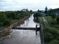
Červený potok (Red creek) which takes the water the highest part of Brdy Highlands, springs between Brda and Tok in an altitude of 775 m of the sea level, flows to the north in the direction to Komárov, here it turns in north-eastern direction to Hořovice and mouths into Litava- river in Zdice. The river basis makes 224 km2. In the upper parts it flows through forests, from Komárov through inhabited area with bank copsesw. The creek-bed is 5-10 m wide and is gravelled , in some places stony, with small rapids. In the last section before the estuary ( where the construction of the highway D5 was finished) the bed is embanked , it was not investigated in more detailed way, so attention – some not-navigable steps and other unpleasant things could occure.
As to tributaries – the Stroupínský potok (creek) is interesting.
The access to the river is possible of the road on many places, this follows the flow along all its length. The railway from Hořovice follows the river as well. We calculate with 4 hours of navigation – for the whole flow.
Accommodation and Food-supply:
It is available in Komárov, Osek, Hořovice, Kotopeky, Praskolesy, Zdice.
First aid:
It is available in health centres in Komárov, Hořovice and Zdice.
Places of interest:
- Komárov: castle of 16th century, the museum of iron-industry
- Hořovice: an old Gothic castle and new Baroque castle with an English park, Gothic, in Baroque style rebuilt church and Baroque church of 17th century,former Franziscan abbey of 17th century, Column of Virgin Mary , synagogue


